The Truth About California Earthquakes
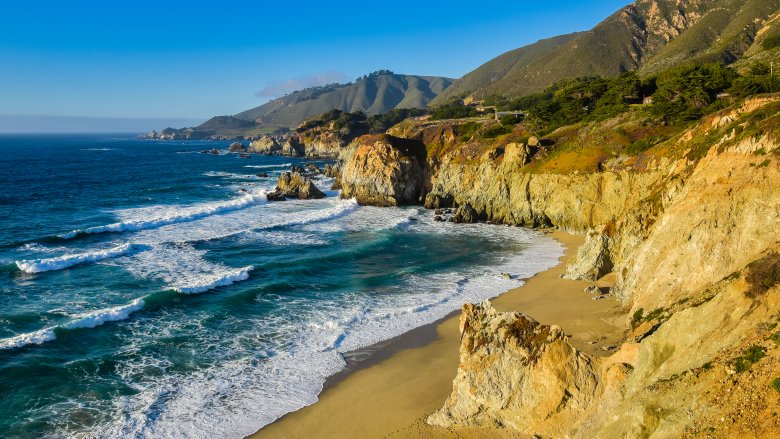
California has it all — skiing, surfing, boating, and hiking, plus desert, forest, beaches, and yoga studios where you can downward dog with your actual dog. Also, at some point the whole state might burn down and a giant earthquake/tsunami will one day flood the entire coast and level a few major cities but hey, it can't be all sunshine and avocado toast.
California is earthquake country. Some areas are worse than others, but generally speaking if you live in the Golden State it's really only a matter of time before the earth moves beneath your feet, and it's probably not going to be because you saw Johnny Depp at a Hollywood coffee shop.
Everyone who lives in California knows it's only a matter of time before the Big One strikes, and when it does it's going to be a mess. Tsunamis could take out the coastline, cities could collapse, avocado crops could fail, and yoga studios might temporarily close. But how close are we to the Big One? And what is the truth about earthquakes in California?
The July 2019 earthquakes were Southern California's first big ones in two decades
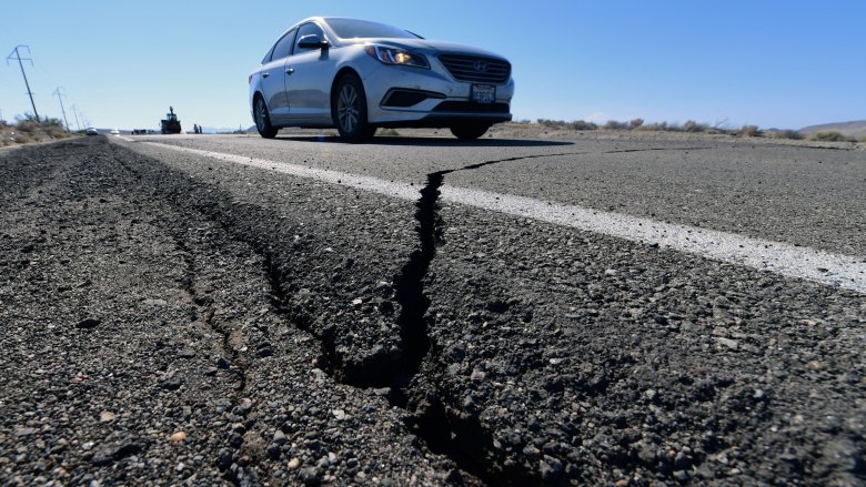
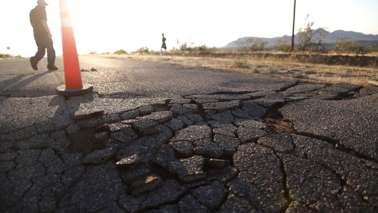
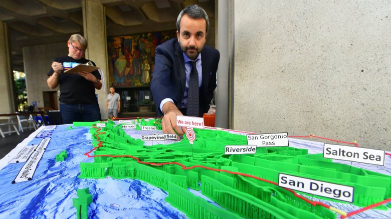
On 2019's Fourth of July weekend, Southern California was struck by two earthquakes. The first, a magnitude 6.4, hit 11 miles from the desert town of Ridgecrest. The second struck the same region the very next day, and it was even bigger — it measured a 7.1.
You might be tempted to think that's just another day in the life of California, but it's actually been 20 years since that part of the state experienced an earthquake anywhere near that size. According to Time, seismologists expect there will be an earthquake in Southern California every few years, so the 20-year gap between these two quakes and the last one (the 7.1 magnitude Hector Mine quake, which struck a remote part of the Mojave Desert in October 1999) is pretty unprecedented. In the decade prior to that, there were a total of eight quakes measuring magnitude 6 or greater.
So that's great news, right? No earthquakes = good. Except seismologists say no, it's not good. In fact, fewer earthquakes means there's a greater buildup of tension along the faults, which naturally means ginormous, devastating earthquakes are just around the corner. Hey trendsetters, time to make the safety helmet a California fashion staple.
The July 2019 quakes were kind of geologically weird
When we think California earthquakes, we think San Andreas Fault. But the July 2019 quakes weren't on the San Andreas, they happened along weird perpendicular faults in a complicated geological area. According to LiveScience, the bigger of the two quakes occurred along a fault in the Little Lake fault zone, while the smaller one occurred on an unmapped fault. But the small quake was really unusual because it was caused by two perpendicular faults slipping at the same time. Seismologists say that kind of event doesn't happen very often, although some also think complicated quakes may be more common than once believed, simply because modern earthquake sensing equipment is a lot more sensitive than it used to be. Still, complex events like the July 2019 quakes are kind of bad news for seismologists, because they add additional challenges to the already way-too complex task of designing earthquake sensing equipment.
The quakes occurred in the same general region as a 1992 and 1999 quake, which might be a sign that the Eastern California Shear Zone is gearing up for more seismological action. No one knows what that might mean, though. More earthquakes or less? Isn't the mystery just part of the fun?
The San Andreas Fault probably wasn't affected by the 2019 quakes. Probably.
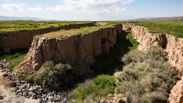
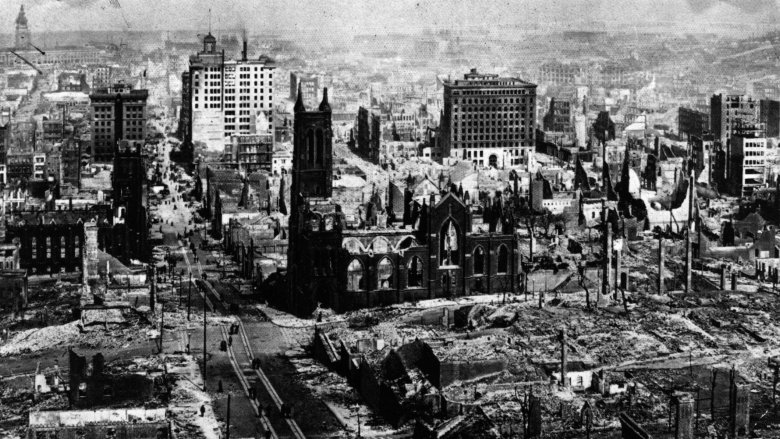
The Little Lake fault zone is really just a bit player in the story of California earthquakes. The granddaddy of them all is the San Andreas Fault, which stretches 625 miles from Point Arena to the Salton Sea. And according to PBS, the San Andreas Fault hasn't had a major quake since 1906, when a magnitude 7.8 famously destroyed pretty much the entire city of San Francisco.
San Andreas is a monster fault. The west side creeps toward Alaska while the east side is constantly moving toward Mexico. And it has the potential for big, sudden movement, too. During the quake of 1906, the fault cut a fence in two and put 18 feet between the two parts.
Earthquakes that happen elsewhere in the state don't lessen the likelihood of a big one on the San Andreas Fault, which has been slowly building up pressure over the decades. In fact depending on where they are located, other earthquakes can potentially increase the seismic strain on the San Andreas, which might actually bring us closer to the Big One. The 2019 earthquakes probably weren't in the right place to affect the San Andreas, though some seismologists think that if the San Andreas Fault is close to slipping anyway, a quake on an unrelated fault might be enough to push it over the edge. And if not then hey, maybe the next 6+ will. What a fun guessing game, right?
California has a buttload of faults
So there's the San Andreas and the Little Lake fault zone we just found out about, but exactly how many other faults are there in California? There can't be that many can there? (Insert pun here.)
Why yes, in fact there can be that many faults. According to Earthquake Authority, California has more than 500 active faults and since 1933 there have been 23 major quakes in southern California alone (a "major quake" is one that measures magnitude 5.9 or greater). In fact if you look at a map of earthquake faults in Southern California in particular, it looks like someone just tossed confetti on the state, if every piece of confetti were its own singular harbinger of destruction.
And that's just the ones we know about — there are still unknown and unmapped faults all over the state. So although seismologists are certainly doing their best, earthquake science still has a really long way to go.
At least climate change can't cause earthquakes ... oh, wait
Hey, but at least climate change has nothing to do with this, right? Yeah, sorry. It kind of looks like climate change might actually be capable of triggering earthquakes, because we weren't already doomed enough.
According to the LA Times, scientists think that earthquake activity in the Mammoth Mountain region in 2017 was triggered by large amounts of snowmelt flowing into the ground water. That sounds kind of silly until you understand how this might work — the earthquake swarms reported at Mammoth were behaving strangely compared to how earthquake swarms usually behave. Usually, fluid migrates upward during a swarm instead of downward, but in this case scientists noted exactly the opposite behavior. So they went back and looked at the data over a period of 33 years and discovered that 55% of the earthquake swarms in the area occurred on the wettest days during years of high snowfall. Overall, the rate of shallow seismic activity was 37 times higher during wet periods than it was during dry periods.
And yes, it's likely all due to climate change, which models have predicted will lead to more and more severe seasons of extreme precipitation, whether that occurs as rain or snow. Joy.
California's earthquake drought is unnatural
What's especially weird about California's long earthquake drought isn't that the San Andreas Fault has been quiet for so long or that the Hayward Fault has been quiet for so long or that the San Jacinto Fault has been quiet for so long — it's that so many of the major faults in the state have kind of been on a synchronized schedule of being quiet, almost as if they were conspiring with each other to really make a mess of things as soon as they're all good and ready.
According to Business Insider, the earthquake silence is so unprecedented that there hasn't been anything like it in the last 1,000 years. So is it all just a weird coincidence? Maybe not. Some scientists actually think that the San Andreas, Hayward, and San Jacinto faults may have synced up, which basically means yes, they are conspiring to make a mess out of things as soon as they're good and ready.
"It's like a game of Russian roulette," seismologist Chris Goldfinger told Business Insider. "Except the gun has 100 chambers rather than six, and several dozen guns instead of just one." Someone please tell seismologists that they're not allowed to do similes anymore, okay?
How big is big for an earthquake?
The largest earthquake on record was a magnitude 9.5, which struck the Bio-Bio region of Chile in 1960. According to the U.S. Geological Survey, that was one of only a handful of 9+ magnitude quakes that the Earth has experienced since we started keeping track. Southern Alaska had a 9.2 magnitude quake in 1964, and there was a 9.1 off the coast of Northern Sumatra in 2004. Another 9.1 struck Japan in 2011, and there was a 9.0 off the coast of Russia in 1952.
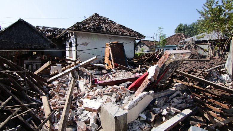
California has fared okay, comparatively speaking. Its largest-ever earthquake was kind of pathetic compared to those 9+ quakes, scoring a mere 7.9 magnitude. That quake hit the San Andreas Fault north of Los Angeles on January 9, 1857. Still, it was powerful enough to uproot trees and make the Kern River flow backward, so "pathetic" is probably not the right word.
In second place is the infamous quake of 1906, which killed more than 3,000 people, destroyed 28,000 buildings, and cost more than $400 million in damage — and that's $400 million in 1906 dollars, so add a whole bunch for inflation.
How many earthquakes is a lot?
It is true that there have only been a handful of major earthquakes in California in the last 100 years or so, but don't let that lull you into a false sense of security. Earthquakes are common. In Southern California there are roughly 10,000 earthquakes every single year, for an average of one every hour or two, 24 hours a day, seven days a week. But before you start thinking that living in Southern California must be sort of the same as having a house in a busy railyard, almost all of those earthquakes are so small that people don't notice them.
According to the U.S. Geological Survey, of those 10,000 quakes only a few hundred are greater than magnitude 3.0, and anything smaller than that is usually not strong enough for normal humans to feel. Magnitude 3.0 to 3.9 earthquakes are sometimes felt, but mostly by people who are indoors on upper floors. Each year there are only 15 to 20 quakes in Southern California that measure 4.0 or greater — that's how big a quake needs to be for people near the epicenter or in the surrounding regions to know for sure they've just experienced an earthquake.
Also, let's clear up some confusion about the Richter scale
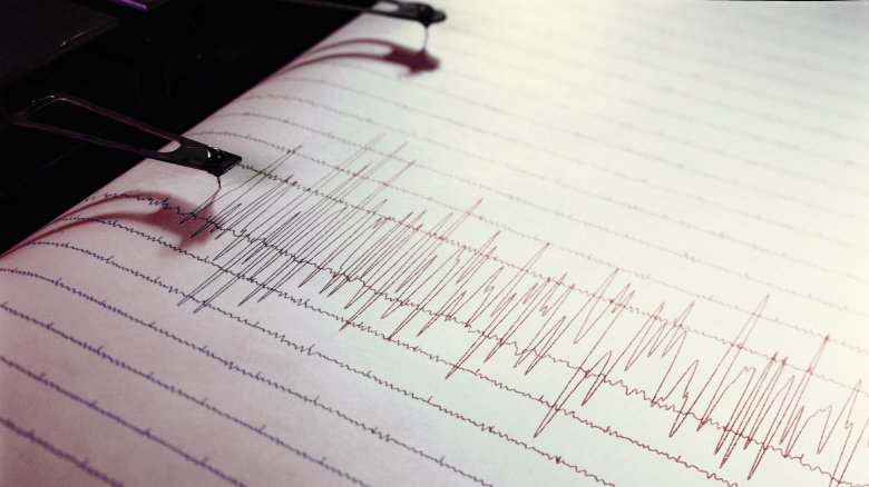
Okay, annoying history side note time: The Richter scale was a confusing-to-calculate and somewhat inaccurate way to measure earthquakes, particularly large earthquakes. We now use the moment magnitude scale, which gives similar-looking numbers but arrives at its numbers differently. Instead of just measuring the waves a seismograph could feel during an earthquake (Richter), the moment magnitude scale adds a whole bunch of other info, like the distance and area over which an earthquake occurs.
Anyway, when you hear those magnitude numbers, you're probably tempted to think that a 5.0 earthquake is just a little more intense than a 4.0 earthquake, the way a 50-pound dog weighs a little more than a 40-pound dog. But that's not how it works. Really, a 5.0 earthquake is huge compared to a 4.0 earthquake. According to IRIS Earthquake Science, each time you add 1 to the magnitude it represents a 10-fold increase in the shaking of a quake and about a 32-fold increase in the energy released by the quake. So a quake that measures a 5.0 is actually 10 times more shaky-feeling (depending where you're standing) than a quake that measures a 4.0, and about 32 times more energetic. If you add 2 to the magnitude (say, a 5.0 compared to a 7.0), the energy increases by a factor of 1,000.
There are even earthquake faults in the ocean
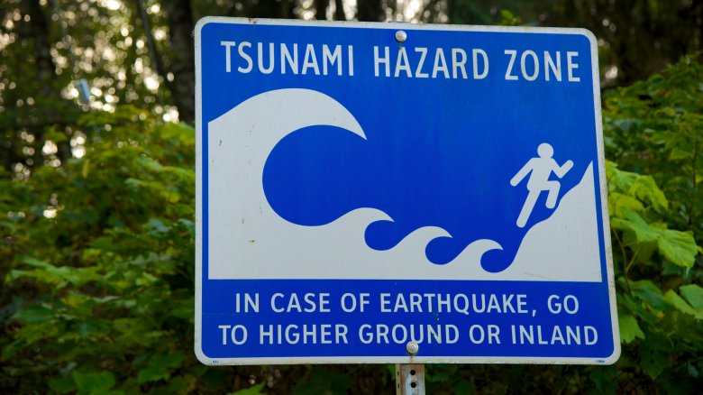
If you had to guess where the Big One will strike, you'd probably guess the San Andreas Fault, San Francisco, or Los Angeles because those are the places that have seen past seismic action. But an equally likely place for the big one is the Cascadia subduction zone, which lies beneath the ocean floor off the coast of the Pacific Northwest. According to the New Yorker, Cascadia is even longer than the San Andreas Fault — it runs from Cape Mendocino all the way up the coast to Vancouver Island. If you've ever visited the beaches of upper northern California, you've probably seen the "tsunami hazard zone" signs, which basically say, "Sure, come on down to the beach, but don't blame us if you are swept away by a tsunami because we warned you."
The last earthquake in the Cascadia subduction zone happened in January of 1700, and seismologists expect to see a quake in that region every 400 to 600 years-ish. That means a big quake is likely in the next 100 to 300 years, maybe sooner, and when it hits it's likely to measure somewhere between 8.7 and 9.2. And seismologists predict that the resulting tsunami will inundate much of the coastline from California to Canada, possibly killing as many as of 13,000 people. So don't imagine that the further north you get, the safer you are. The U.S. west coast is pretty much a death trap from border to border. But hey, good scenery!
Why can't science predict earthquakes?

Science has given us an early warning system for pretty much every natural disaster there is. Thank you, science. We can predict tornadoes, we can see hurricanes coming, and even volcanoes give us some sense of when they're planning on inundating a few thousand square miles of towns and farmland. But there are two types of disasters scientists still can't predict and behold, both of them are common in California. The first is wildfires — sure, you can estimate the risk based on things like wind speed and how much dry vegetation there is, but you can't predict where and when a spark might turn the whole thing into a roaring inferno.
Scientists also can't predict when and where the next earthquake will be. And it's not that seismologists don't know a lot about why earthquakes happen, it's just that they haven't been able to develop equipment sophisticated enough to give us more than a few seconds' notice. Instead, scientists are forced to use statistics to determine the probability of an earthquake happening in certain places, but that is a pretty imperfect science.
Earthquake aftershocks can go on for years

Most people with a rudimentary understanding of earthquakes know that big earthquakes tend to be followed by smaller earthquakes or aftershocks, which seem specifically designed to nurture PTSD in everyone who lived through the first big quake in the series. If you don't live in California or some other earthquake-prone area, you might have also assumed that aftershocks only happen for a few days or weeks following the major quake, but the truth is that aftershocks can go on for years.
According to the Southern California Earthquake Center, the magnitude 6.7 Northridge quake struck on January 17, 1994, and then spawned more than 13,000 aftershocks over the next three years. And we're not talking about progressively diminishing aftershocks, either — the one that struck on April 26, 1997, more than three years after the initial event, measured a 5.0.
Also, aftershocks can have aftershocks, and can sometimes be foreshocks for other aftershocks, and because the aftershocks can seem to go on forever and ever pretty much everyone who didn't grow some sense and move to Florida — where you only have to worry about hurricanes, alligators, and old people drivers — gets to have regular reminders of the fact that the earth could open up beneath their feet at pretty much any moment. Isn't nature a wonderful place.
What about that earthquake early warning system?
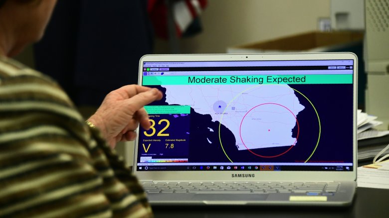
Scientists still can't predict earthquakes, at least not with the kind of advance notice that's really needed for everyone to get to safety. But that doesn't mean California has to remain totally blind to the impending danger.
According to CNN, California plans to implement an early warning system over the entire West Coast, which ideally will alert residents to an impending quake before the shaking actually begins. Here's the catch, though: The system is expected to give notice anywhere from seconds before to the moment the shaking begins, which frankly does not sound super useful to the average person. The system works by detecting the energy of the first seismic wave, which doesn't typically cause damage but can provide enough information to help scientists guess at the quake's magnitude. The alerts go out just after that, ideally before the more destructive second wave. The closer you are to the epicenter, though, the less time you'll have and some very close people won't receive an alert at all, so basically, those who need a warning the most won't get one.
The hope, though, is that those few seconds will otherwise be enough time to stop cars from entering tunnels or crossing bridges, for people to exit buildings or take cover under desks, and for trains to slow and taxiing planes to stay on the ground. So that's better than nothing, and at the moment, better than nothing is all we have.