Airport Runways That Will Make You Poop Your Pants
The invention of the airplane truly brought the world together. For the first time in history, we could zip between countries in a fraction of the time it took on the old pony express, baby elephant walk, or camel trek—and with far fewer funky odors too, aside from the airline food. Despite the convenience of flight, some of the most breathtaking and remote locales also come with one caveat: a truly frightening takeoff or landing. We've fit runways into places that they have no right to fit into. The next time you visit any of these travel destinations, make sure you bring an immediately accessible change of underwear. Here are the most terrifying runways in the world.
Princess Juliana International Airport in St. Maarten, Caribbean
Christopher Columbus apparently spotted the small island of St. Martin, perhaps anchoring off the coast, but thankfully for the locals, he never set foot upon it. St. Martin/Maarten was initially settled by the Caribs, before the Spanish, and then the Dutch, French, English, and Danes all battled for control of the island. Eventually, the French and Dutch agreed to share the roughly 34 square-mile island, so it should have killer chocolate escargot. These days, the Caribbean outpost has a combined population of around 80,000 Frenutch folks, who speak a variety of languages, although English (and dollar signs) is the most common language.
Despite its bizarre, split history, St. Martin has become a mecca for sun seekers. Touristas flock to the Dutch side of the island for its hoppin' nightlife, casinos, and rum and guavaberry beverages, while the French side features clothing-optional beaches, outdoor markets, and French-Indian cuisine. No matter the side you're intending to hit up, you still have to fly into Philipsburg, where Princess Juliana Airport and its intense runway await.
Named for the mid-century Dutch princess and popularized on YouTube by vacationers, who often shoot videos of planes soaring mere meters above Maho Beach, the scary airport features the infamous Runway 10, which begins and ends over Simpson Bay (d'oh!). Juliana's runway is longer than many other freaky-small runways—topping out at 7,500 feet long—and the landings are probably more terrifying to beach-goers than passengers. However, takeoffs do pose serious hazards for pilots (and the nerves of anyone with a window seat), since the plane is immediately forced to bank away from mountains along the departure path.
You can relax, though, as there have been no recent major incidents reported with regards to the abrupt beachhead runway.
Courchevel Altiport in Courchevel, France
If you're a world-class skier or snowboarder, you know several mountainous regions around the world offer prime opportunities for shushing down the slopes. Few provide finer gravitational challenges than the European Alps. However, some parts are a little trickier to hit up than others. One such place is the Tarentaise Valley in the Savoy region of France.
Ski bliss incarnate, Les Troise Valley features a condensed clutch of graduated ski resorts, named by their elevation (e.g., Courchevel 1300, 1550, 1650, and 1850). After the second World War, the French ski communes were expanded into retreats (much to the chagrin of toboggan and curling enthusiasts everywhere), and the resort region began hosting minor and even major events, such as spillover from the 1992 Olympic Winter Games in nearby Albertville. Hard-core downhill enthusiasts and thrill-seekers face one major mogul, though, before they can even drop in on their ski vacation: Courchevel Altiport.
The micro-airport is located roughly 6,500 feet above sea level and tests even experienced pilots with its upward-sloping runway. If that weren't heart-pounding enough, the small engine crafts only have about 1,800 feet to touch down and come to a complete stop. That doesn't even include the joys of approach, including potentially icy runways and a dearth of lighting that makes foggy landings a borderline death wish.
Cristiano Ronaldo Madeira International Airport in Santa Cruz, Portugal
The chain of islands known as Madeira was first annexed for Portugal in 1412 by Infante Dom Henrique, better known to English-speakers as Prince Henry the Navigator. After its colonization, it became an important agricultural producer for the world power, providing wine and sugar income, along with the requisite daily allowance of sunny walks on the shore. In the late 19th century, William Reid opened the first major hotel on the archipelago, and the upper crust flocked to the tiny island, including dignitaries like Winston Churchill and literati like George Bernard Shaw.
It wasn't until the late 1960s that Madeira Airport opened up, and the balmy coastal Mediterranean air and coastal charms brought tourists to the region like lepers to a colony. The island doesn't feature beaches but has a lovely irrigation system (more appealing than it sounds), natural waterfalls, and mountainous hikes for the outdoorsy types—or wilderness pretenders with calf muscles that scream for mercy. The true challenge is arrival, though, since the flight could give you and your pilot day and night terrors.
Recently renamed after superstar footballer Cristiano Renaldo, who was born on the island, Madeira International Airport rests on the eastern edge of the small Portuguese island, in the municipality of Santa Cruz. Navigating around Renaldo's ego isn't the only challenge for pilots, though. They'll also face a gut-churning landing along the runway, which was at least extended from 1,600 feet to nearly 2,800 feet, thanks to a constructed platform—which sounds a bit scary on its own. Longer strip or not, the unpredictable winds and hills around the airport still make landing a risky business, even without a top gun on the flight controls.
Paro International Airport in Paro, Bhutan
Paro was built along an important trade route with Tibet, on the eastern edge of pint-sized Bhutan, one of the most mountainous countries on the planet. Paro is home to the ancient monastery of Rinpung Dzong—which most Westerners can't say three times fast—an abbey constructed during the 10th century, which also doubled as a fortress. In addition, it was purportedly home to the man responsible for bringing Buddhism to Bhutan, Guru Rinpoche. As a result, the small village hosts countless religious pilgrims every year, in addition to roughly 30,000 high-altitude sightseers, roughly twice as many annual visitors as full-time residents. Aside from history, culture, and a few souvenirs, tourists can also pick up more than a few wrinkles upon arrival, and then a few more after departure.
Easily one of the most perilous runways in the world, tiny Paro airport is located roughly 7,900 feet above sea level. The sole international airport in Bhutan really isn't much more than a landing strip, which at only 6,500 feet long is shorter than it is tall. The facility is also ringed by a jagged mountain range and wedged between two massive, 20,000 foot peaks. To this day, only a scant few pilots are genuinely qualified to land here, so scrutinize your aviator's credentials before soaring in.
Tenzing-Hillary Airport in Lukla, Nepal
Some of us reach for the pinnacle by climbing to the top of a pile of dirty laundry, planting a flag by the washing machine, and then taking a long nap. Others, who fall into that overachiever category, find themselves trekking along the twisting road to Mount Everest. Before arriving at the legendary Nepalese spire, though, those striving to conquer the world's highest mountain—or at least hazarding a glance up its snowy spire—have to endure a different kind of challenge: flying into the tiny town of Lukla.
Denoted the "world's scariest airport" by more than one publication, the Tenzing-Hillary Airport—named after Sherpa Tenzing Norgay and his climbing partner Sir Edmund Hillary—lulls travelers in with its almost invitingly tranquil name, before exposing unsuspecting would-be hikers to more air terror than most other landings combined. It's perched amid the towering Himalayas at 9,100 feet above sea level, and flyers can marvel at the gorgeous peaks before transitioning to a bowel-loosening landing along the air strip's scant 1,729-foot runway.
Arrival may be the most frightening part of the journey, but the return flight offers its own nail-biting aspects. Planes are required to hit flight speeds pretty darn quick before the runway drops off some 2,000 feet. Thanks to unpredictable winds and the minute landing area, numerous planes have crashed at the airport, giving Lukla's little hub the bonus title of the most dangerous airport in the world. We'll stick to climbing dirty shirts.
Gustaf III Airport on St. Barthélemy
Born of volcanic rock and colonialism, St. Barthélemy Island is part of the French West Indies in the Caribbean Ocean. Good old Christopher Columbus was one of the first Europeans to set foot on the island, naming it after his brother Bartolomeo in 1493, even though it probably had a perfectly good name beforehand. The French first settled on the tropical island in the mid-1600s, before selling it to Sweden in 1784—something the arctic Scandinavian nation was likely stoked about. Apparently, France developed sellers' remorse, though, and repurchased St. Barthélemy in 1877.
The 9-square-mile island has a permanent populace of just over 7,000 at present, and the salty sea breezes and sultry ambiance turned St. Barts, as it's commonly known, into a luxury resort. Each year, hundreds of thousands of tourists flood the local economy, staying in upscale hotels and trampling the local flora in overpriced sandals—although the Reserve Naturelle does its best to curb environmental damages. Before most airborne plagues, er, guests arrive, however, they face a task far more daunting than discovering the bottom of their tropical mixer: final approach.
Gustaf III Airport, also known as St. Jeans, was named after Swedish King Gustav III—much like the capital burg of Gustavia. Situated right near the beach, the 2,100-foot runway features two different approaches, both of them uniquely challenging. Without a doubt, runway 10 is the trickiest, as it requires navigating between two small peaks, soaring over a highway full of gawking tourists, and dropping the plane onto a downward-sloping embankment. Overshooting the short runway also means an abrupt and unexpected dip into crystalline blue waters. Incoming aircraft also soar very close to a risky highway overlook, leading to more than a few close calls with foolhardy photographers from time to time.
Gibraltar International Airport
Gibraltar has a long history stretching back to Neolithic times and may have been the last roosting place of Neanderthals, aside from Geico commercials and Pauly Shore movies. The stone-named burg sits at the end of the Iberian Peninsula and enjoys a strategic significance to this day, thanks to its prime real estate along the 8-mile-wide Straits of Gibraltar. Even though the small land mass juts into the Mediterranean from the southern coast of Spain, the British have enjoyed the run of the place since the conclusion to the Spanish War of Succession in 1713—something that's still a minor point of contention between Spain and England, despite their endeavors at sharing.
The 2.6-square-mile settlement boasts a permanent population of 30,000 and has become a serious holiday hotspot due to its clement coastal locale and its giant rock. Intent upon enjoying the famous stone wedge, scoping the Moorish architecture, or imagining Kevin Sorbo hanging out near the Pillar of Hercules, roughly 10 million visitors set foot in Gibraltar every year. Of those, nearly 450,000 travelers chose to soar into the country via the local terminal and its potentially cheek-clenching landing.
Owned and operated by the British Ministry of Defense, Gibraltar International Airport isn't known for a microscopic runway—that checks in at a very reasonable 5,500 feet long—as much as what it crosses. Each plane is forced to taxi through a sea of vehicles and other commuters, as it touches down across the very active Winston Churchill Highway, one of the main thoroughfares connecting Gibraltar and the Spanish mainland. Landings and takeoffs are carefully regulated, but one discarded hamburger wrapper or careless driver could cause serious mayhem for a speeding aircraft. Fortunately, the only typical issues are cranky motorists stuck behind the very heavy gates.
Matekane Airstrip in Lesotho, Africa
Completely landlocked by the larger nation of South Africa, the Kingdom of Lesotho lies at the southeastern edge of the continent. A small sovereign democracy with a population under 400,000, Lesotho gained independence from the United Kingdom in 1966 and decided its old name, Basutoland, just wasn't hip enough. After a series of reforms stripped the king of his political might in 1993, leading to a series of brutal protests and military interventions from South Africa, the country has stabilized. It's also one of the few constitutional monarchies remaining in Africa.
Nicknamed the "Mountain Kingdom," since nothing in Lesotho is less than 1,000 feet above sea level, the small realm is unsurprisingly ringed by majestic spires. That doesn't mean mountains are the only source of entertainment here, as natural wonders such as Maletsunyane Falls contribute to the country's diverse landscape, one that also allows wildlife lovers to get up close and personal with Africa's exotic species at Liphofung Nature Reserve. If human nature is wild enough for you, though, Lesotho also contains some seriously ancient human history at the Ha Kome Historical Cave Dwelling.
Since there are several airports in the small nation, most of us won't have to encounter Matekane Airstrip in Southern Lesotho. Doctors headed for a very remote house call or charity workers making a donation to your gray hair collection, though, may encounter this intense little strip. Don't be suckered into a false sense of security by the majestic peaks around you, as the final approach is all white-knuckle. The runway itself is little more than a gravel road cut across a 2,000-foot plateau. Presuming you hit your mark, the pilot has a tense 1,300 feet before, uh, well, not a whole lot aside rocks, dirt, more rocks, and probably flipping bum over tea kettle onto the arid terrain. If there's any consolation, your nerves will probably be so shot they'll be numb for the return flight.
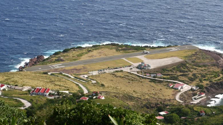
Juancho E. Yrausquin Airport on Saba Island
The tiny port au call known as Saba Island has a long history stretching back to at least the Ciboney hunter-gatherer tribe. Since then, the South American Arawaks also migrated to the island, before a clutch of marooned Englishmen dragged themselves onto its lovely shores and claimed it for themselves. In 1640, the Dutch West Indian Trading Company took possession of the island, although British pirate Henry Morgan (or Captain Morgan for all ye rummies, says I) did his best to chase them arrff, er, off. Since then, Spain, England, France, and the Netherlands have all vied for possession of the 5 square miles of beachfront and volcanic forest. Seeing as the somewhat ironically named volcano, Mount Scenic, is the tallest point in the Dutch Empire, there might be a Napoleon Complex thing to the Netherlands' interests. Either way, 5 miles doesn't allocate much real estate for landing a plane.
As a result, Juancho E. Yrausquin Airport—named and subsequently misspelled after Aruban Minister Juancho Irausquin in 1963—boasts one of the smallest commercial runways in the world at 1,312 feet. The short strip also begins and ends its run over the shimmering, azure depths of the Caribbean. Such a narrow margin of error means it's extra-important to double-check your pilot's credentials, as well as his rum intake. Otherwise, your first visit to Saba's capital, The Bottom (don't get cheeky on us here), might leave you beneath the bay.
If you're looking for a real thrill ride, though, the short jaunt between the tiny isle of St. Maarten and even tinier Saba Island and their micro-ports could be the most frightening 15 minutes on any tropical tourist's flight plan.