The Most Endangered Lakes In America
The good news is that thanks to the creation of the Environmental Protection Agency in 1970 and laws such as the Clean Water Act and the Safe Drinking Water Act, American lakes are doing far better than they had previously. However, the country's lakes are not out of the woods yet. In a certain sense, lakes have always faced pressure as water sources; human water demand grows as does the human population (to say nothing of wildlife), and water is absolutely necessary to life as we know it, explains Astrobiology At NASA. But even as society takes a more ecologically-minded stance to save and preserve local water sources, old threats remain and new ones rise up. The water problem didn't necessarily go away, it just changed with the times, states the WWF.
Impacted by climate change, a megadrought now grips the entire American West, drying up lakes, rivers, and reservoirs alike, notes The Guardian. Fertilizers spawn harmful algal blooms. Heavy metals, the result of industrial waste and processes, settle on lake beds and will continue to persist for generations long after the said industries have switched to cleaner energies. Unfortunately, pollution is a problem that humanity has no choice but to solve or suffer the consequences, including losing these water sources. Here are some of the most endangered lakes in America.
Lake Mead
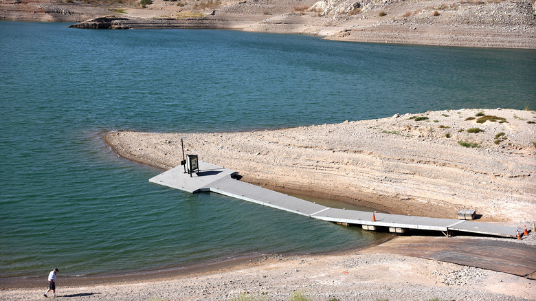
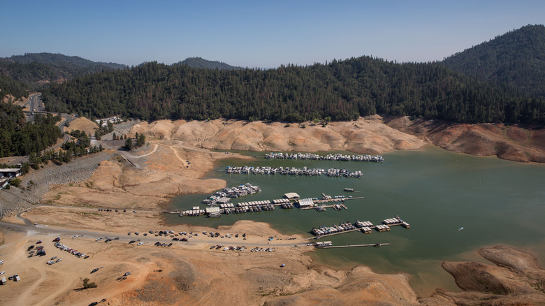
Located on the Nevada-Arizona border, Lake Mead experienced a rise in levels with the 1935 completion of the Hoover Dam. A godsend to the arid surroundings, the reservoir not only became a popular destination in the middle of the Sonoran Desert but as NASA also notes it provided irrigation for 5 million acres and supplied water to over 40 million people, while Las Vegas alone gets 90% of its water from the Mead (per Vox).
But, as Scientific American explains, things took a downturn in 2000 when a megadrought hit the entire American West. Defining a megadrought as a period of severe dryness lasting several decades, the article also explains the region has not seen such water scarcity since 800 A.D. NASA estimates that the Mead should have a capacity of 9.3 trillion gallons of water, but hasn't reached that level since 1999.
In 2022, water levels at Lake Mead became disastrously low, states CNN. According to The Atlantic, the Mead stands at just 30% capacity, even with water restrictions now in place. The diminishing water level afflicting the reservoir is consistent with the consequences of climate change; the Colorado River gets its water from snow in the Rockies, but drought conditions mean less snow is falling, so less water is going into the river.
Lake Powell
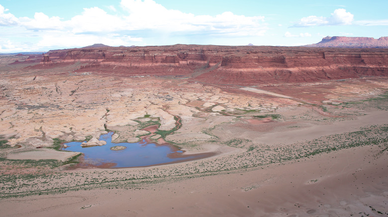
Lake Powell is formed by the Colorado River, and its fortunes are shrinking fast. Created by the construction of the Glen Canyon Dam in 1963, Lake Powell was at capacity (24,322,000 acre-feet) by 1980 and reached from Arizona to Utah. However, as NPR observes, as of 2022, the Powell is affected by the 22-year-long drought impacting the rest of the Colorado River basin and is at just over 25% percent of its 1980 high.
For workers at Glen Canyon's hydroelectric facilities, this dramatic loss is forcing a choice between agriculture and hydropower. And as CPR News reports, the general consensus is to keep the lights on, leaving farmers high and very dry. Moreover, The Salt Lake Tribune warns that the move could wipe out desert agriculture in parts of the Colorado River basin, crippling communities depending on crops for income. The same article warns of the possibility that Powell may vanish entirely and render Glen Canyon Dam inoperable no matter what.
Lake Okeechobee
Despite its impressive size (730 square miles), Lake Okeechobee in Florida is actually fairly shallow, with an average depth of only 9 feet. Meaning Big Water in the native Seminole language, Okeechobee is the largest lake in the southeastern United States and a vital part of the Everglades, explains South Florida Water Management District.
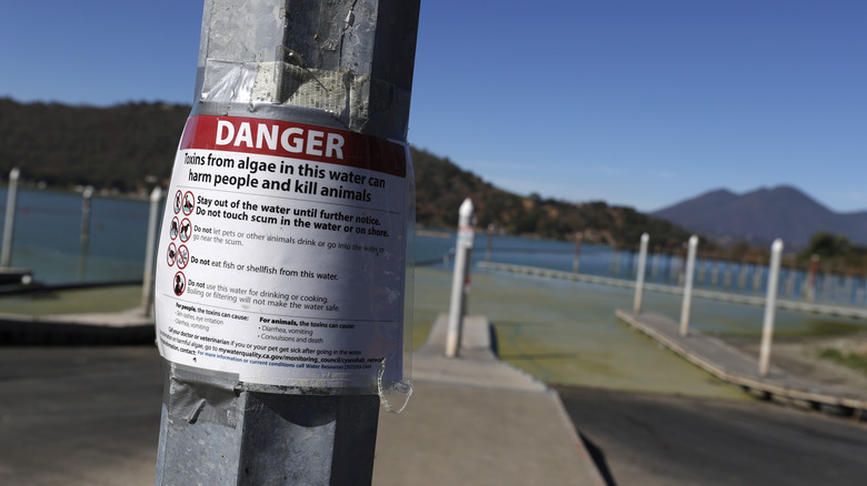
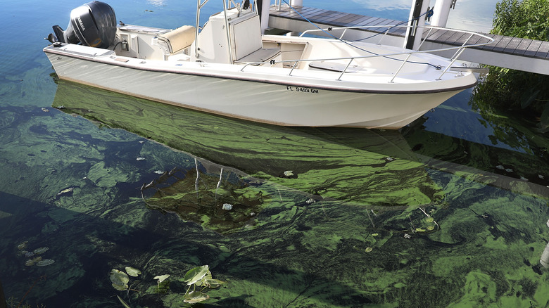
According to Calusa Waterkeeper, the lake has long suffered from human development along its shores, and, more critically to the watershed, agricultural runoff. Loaded with fertilizer, this affluent enters the Okeechobee and sets off massive algal blooms. According to the Environmental Protection Agency, these blooms can turn water into a thick, green slime that blocks sunlight, chokes fish, and, once they die and rot, drain the oxygen from the lake water and release harmful toxins.
In 2022, Marin County officials warned of just such a bloom, advising people to stay out of the Okeechobee, not to drink the water, and wash themselves if exposed (via WUSF). After dredging the lake as part of a rehabilitation program, the Environmental News Network reports that years of fertilizer and pesticide exposure have left parts of the Okeechobee lakebed with four times the land limit for arsenic. At such high levels, experts are unsure what to do with the 1.9 million cubic yards of affected mud.
Lake Shasta
A YouTube report by the Wall Street Journal found that a staggering 90% of water in the west goes to agriculture. Located in northern California, Lake Shasta, already under pressure from drought, was being irrigated into oblivion. That is until officials turned off the tap, which created a host of other problems. A vital part of both California's Central Valley water system and its famously productive farming sector, this artificial lake began filling in 1944 with the completion of the Shasta Dam on the Sacramento River (via National Park Service). But as CNN reports, the Shasta hit critical lows in 2022 — and the traditional dry season hadn't even started.
At just 40% capacity, Lake Shasta is so low that officials now ration what little water remains. Communities such as Silicon Valley will only get this water for health and safety purposes, while 350,000 acres of farmland will be left fallow. The CNN article has officials warning that 2022 will be a terrible year for the state's farming sector, with the only question being how bad it will get. A study by the California Department of Food and Agriculture found drought-related losses in 2021 alone amounted to $1.1 billion, with around 8,750 jobs lost.
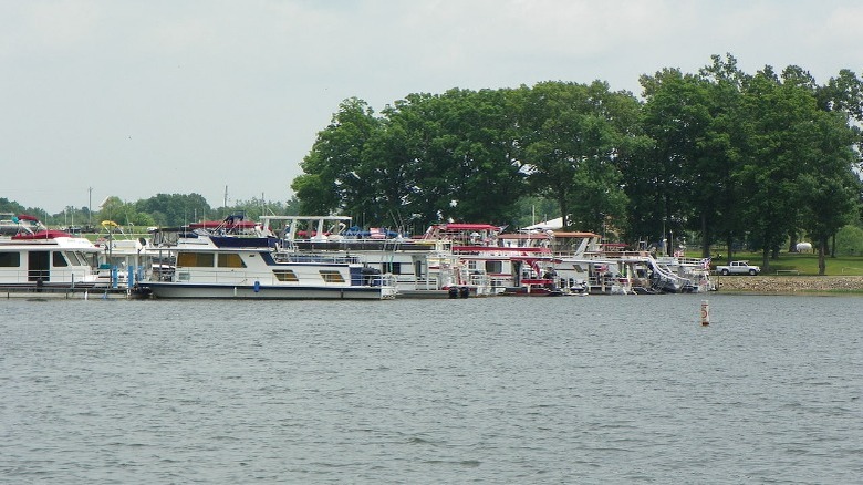
Lake St. Clair
A pitstop between the Great Lakes of Huron and Ontario, Lake St. Clair is nothing if not a hard worker. A conduit for trade, an international body of water, and a recreational hotspot, St. Clair has also seen its environment degrade thanks to years of human development, plus squabbling between the U.S, and Canada over who is to blame.
As reported by Great Lakes Now, nearly a trillion gallons of sewage-laden water have flowed into the lake since 2000, setting off E. coli outbreaks and algal blooms so harmful that beaches have been closed for months at a stretch every year. According to the Detroit Free Press, human mismanagement is making the matter worse: testing of the tributary waters was scaled back, a public water quality board disbanded, and a chemical spill monitoring system was suspended.
All of this is on top of having one of the most famously industrial cities in America right on the lakeshore. As the Detroit Free Press explains, PCBs and heavy metal pollution from Detroit have prompted officials to place more stringent fishing restrictions on Lake St. Clair than anywhere else in Michigan. The costs to rectify the faulty, antiquated, and even illegal sewer systems are estimated at a mind-boggling $26 billion.
The Great Salt Lake
The Great Salt Lake in Utah has, in a sense, been drying up for millennia. The current body of water is but a drop of the former Lake Bonneville, a 20,000 square mile behemoth existing until about 16,000 years ago. As there was no outlet, the Bonneville could only evaporate, leaving what remains as saline. Indeed, the present Great Salt Lake can be two to seven times saltier than the oceans.
But as Deseret News reports, salt isn't the problem. Rather, in a normal year, the lake is fed by runoff from snowpack, but the 22-year drought gripping the American West, in addition to local water diversion for irrigation and municipal demand, has experts and residents openly worrying that the Great Salt Lake is in danger of drying out completely. The estimated economic damage would be devastating: a further 10-foot drop in water levels would inflict a $1.3 billion hit to the mineral extraction industry, $81 million in lost recreation, and a further $67 million loss in the brine shrimp industry. This would be on top of health issues rising from salt-laden dust blowing up from the dry lakebed.
Lake Kinkaid
In a damning 2004 article on human impact in Illinois, The Daily Egyptian reports that Lake Kinkaid is emblematic of all lakes in the state: every last one suffers from mercury pollution. Lake Kinkaid is simply the worst. Located in the far south of Illinois, Lake Kinkaid's woes stem from the emissions originating from coal-burning power plants. According to The Daily Egyptian, the 23 coal-fired power plants that generate power across Illinois, release around 6,000 pounds of mercury annually. That pollution eventually ends up in the state's lakes, where it is consumed by fish and any human that eats them. As an element, mercury is persistent and once it enters an environment, like Lake Kinkaid, it stays there. It is also extremely toxic, notes the EPA, exposure to mercury can affect everything from vision to cognitive ability and fine motor control.
Things have not improved since 2004. LakeLubbers, a popular vacation information source, recommends avoiding certain Kinkaid fish species for consumption. In fact, at Lake Kinkaid alone, six different fish species are on a warning list issued by the Illinois State Department of Public Health. Despite this, the lake is still a nationally-recognized angling hotspot. According to National Geographic, half of the power in the United States comes from burning coal, with no end in sight. Therefore, unless there is a concerted change to green energies, water sources such as Kinkaid will continue to be poisoned.
Mono Lake
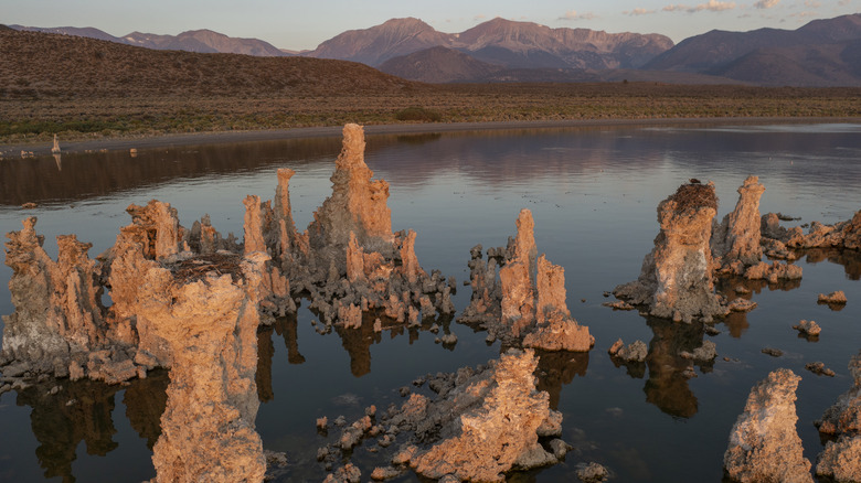
Famous for its eerie towers of calcium carbonate, Mono Lake in California is at least 1 million years old. Filled from the Sierra Nevada with water laden with minerals and salts, evaporation has left the Mono over twice as salty as the ocean. But as with all water sources in the American West, a 2-decade-long drought has reduced Mono Lake so severely that it can no longer provide water to thirsty populations elsewhere. As the Los Angeles Times reports, in 2022, officials announced a 72% reduction in the amount of water the city of Los Angeles can divert. Additionally, the Mammoth Times explains that the megadrought and water diversion projects have left Mono Lake 11 feet below the state's established management target, 1.5 feet lower than in 2021, while alpine runoff, the lake's lifeblood, is at just 58% of the average.
Unlike other water sources, however, Mono Lake is also a battleground between water demand and conservationists. The lake is a wildlife haven, and an island in the middle of the Mono serves as a habitat for several bird species, however, low water levels could create a land bridge allowing mainland predators onto the island. Another issue is air quality; the salt swept up by wind is so severe it triggers clean air act violations.
Utah Lake
Located south of the Great Salt Lake that it feeds, Utah Lake is described by the state Department of Environmental Quality as hypersaturated with nutrients from industrial and stormwater discharges, wastewater treatment plant effluent, and runoff. The result is large-scale seasonal algal blooms, which lead to cyanotoxin production, and elevated pH levels, all harmful to both humans and wildlife. This is on top of the megadrought gripping the region. The lake is at just 54% of its full capacity as of 2022, and as photos by KSL TV show, the water level is so low that the geography of the shoreline has changed.
However, Utah Lake is also subject to a massive rehabilitation project; according to a report by FOX 13, officials expect the Utah Lake restoration project will provide 30 billion gallons of additional water to the state via water conservation, storage, and purification endeavors, along with environmental plans including the elimination of invasive species. Deseret News reports, that the idea for the eye-watering $6.5 billion project involves constructing 34 artificial islands, 190 miles of new shoreline, and dredging to deepen Utah Lake's fairly shallow depth of 9 feet. Much is still in the works, and not without its critics. Nevertheless, considering Utah is the second driest state in the U.S.A., the project already has the approval of several lawmakers.
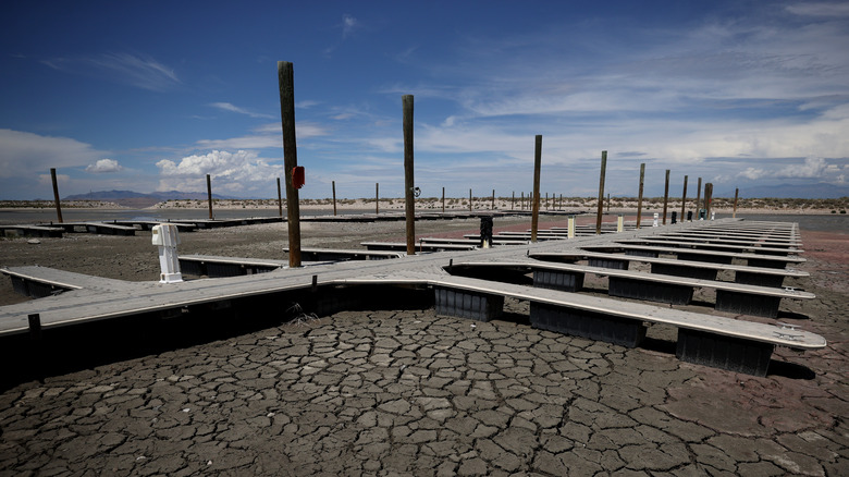
Salton Sea
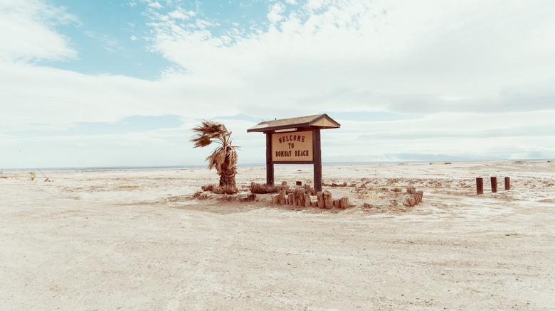
According to the California Department of Parks and Recreation, the Salton was formed in 1905 when flooding on the Colorado River burst the canal gates leading to the developing Imperial Valley and poured into a salt-encrusted depression then called the Salton Sink, and it was not until 1907 that engineers finally got the break under control. In the interim, a saline lake 45 miles long and 20 miles wide formed. Seeing an opportunity, officials turned the new Salton Sea into a vacation getaway. When the canals were repaired, agricultural runoff picked up the slack, topping up the water.
But as Audubon reports, the decades-long drought hitting the West Coast means there is less water in the Colorado River and the adjacent farmlands next to the Salton. Thus, the Salton Sea is returning to the desert it had been and is now even saltier than the Pacific. According to The Verge, the years of fertilizers that accumulated in the exposed lake bed are being thrown into the air by strong winds, creating and killing asthmatics. What had been the epitome of an oasis is now a toxic desert.
Lake Onondaga
It should be said that a concerted clean-up effort at Lake Onondaga has vastly improved the situation at a body of water once known as the most polluted lake in the United States, states the EPA. That being said, things are far from rosy at this lake in upstate New York. Like so many cases of lake pollution, Onondaga's woes can be traced directly to human industry. According to a study by Syracuse University, 165,000 pounds of mercury were released from 1946 to 1970 into the Onondaga, affecting 7.3 million cubic yards of lakebed sediment. The Onondaga Nation reports that the pollution came from just one company, Allied Chemical Corp., now a part of Honeywell International, Inc. Honeywell was mandated to clean up after itself, but even with such efforts, the fish in the lake still remain contaminated.
If that wasn't enough, the New York Department of Environmental Conservation notes that the Onondaga faces impacts from ammonia and phosphorus, derived from sewage regularly flushed into the lake from human settlements. This caused algal blooms, leading to murky water conditions and decreased oxygen. The same study adds that pesticides, fertilizers, salt from roads, and animal waste all find their way into the lake.
Devil's Swamp Lake
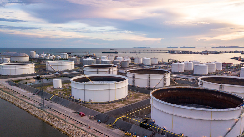
In 2015, the Louisiana Department of Health warned against anyone swimming there. In 2020, the state's Department of Health and Hospitals warned residents not to eat anything caught there. While the name Devil's Swamp Lake certainly doesn't promise rainbows and unicorns, how did a lake just 10 miles from Baton Rouge get so dangerous?
According to the EPA, rapid industrialization throughout the '60s and '70s resulted in numerous waste storage sites and subsequent releases of hazardous substances in the areas surrounding Devil's Swamp. All of this stemmed from a rise in the Louisana petrochemical industry, whose waste (mostly mercury and PCBs) was stored in sub-par landfills and receiving basins that eventually leached their way into the lake. The situation became so critical, that Devil's Swamp Lake was declared an active Superfund site in 2020 by the EPA, however, reports of the lake's dangers go all the way back to the early 1980s.
In a bitter irony, none of this comes as news to the 1,598 residents who have been living around the lake all their lives. In a report by local TV station WAFB 9, locals had stopped eating fish and crawfish at Devil's Swamp Lake years before any warning came from state or national agencies, and had protested when industries set up shop on the lake's shores back in the 1960s. One resident mourned the lake where he had played as a child, saying it was now a cesspool.