Sandy Island: The Mysterious Place That Was On The Map But Never Actually Existed

Per Statista, Google's web mapping platform is the most popular navigation application in the United States. Over a billion drivers worldwide use Google Maps every month to find directions, real-time traffic alerts, and the best available routes to reach their destination (via Google Cloud). In addition, according to PC Magazine, the application gives users an option to share their live location with loved ones to feel connected and safe.
Though it was designed to make people's lives easier and help them find each other quickly, Google Maps can misdirect and unintentionally confuse its users. For example, in India, per Catch News, a traveler in Mumbai was shocked to see the Uber he booked was stationed in the middle of the Arabian Sea. In addition, it once lost a city of 90,000 residents in Florida and redirected visitors to Sarasota, 200 miles away (via CNN).
According to the New York Post, Google Maps users recently spotted a ghost image of a downed airplane nestled in a clearing in the north Queensland rainforest. However, one of the most bewildering finds on Google Maps remains Sandy Island — a Manhattan-sized piece of land in the South Pacific between Australia and New Caledonia "undiscovered" by scientists ten years ago.
The unsolved riddle of a non-existent island
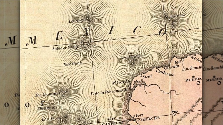
Per The Daily Express, British explorer Captain James Cook first included "Sandy I" in his "Chart of Discoveries in the South Pacific Ocean" in 1776. The 15-mile long and three-mile-wide Sandy Island was first "discovered" in 1876 by a ship named Velocity, reports The Washington Post. It was mentioned on a British Admiralty chart in 1908 and became part of the U.S. military's World Vector Shoreline Database (via LiveScience). Interestingly, the French hydrographic office termed it a phantom island and removed it from its charts in 1979. Yet, it disappeared and reappeared on many nautical charts and scientific maps, including the National Geographic Society, the General Bathymetric Chart of the Oceans, and Google Maps.
According to The General Bathymetric Chart of the Oceans, the mysterious island was reported "missing" in November 2012 after an Australian research ship on a 25-day geographical expedition to identify fragments of the Australian continental crust passed through its location and couldn't find it. "We wanted to check it out because the navigation charts on board the ship showed a water depth of 4,620 feet in that area — very deep," said Dr. Maria Seton, a marine geoscientist at the University of Sydney, per BBC. "It's on Google Earth and other maps, so we went to check, and there was no island. We're really puzzled, it's quite bizarre. How did it find its way onto the maps? We just don't know, but we plan to follow up and find out."
Did the ghost island sink due to climate change?
Though Sandy Island no longer pops up on Google Maps after Dr. Maria Seton's team concluded it didn't exist, there is no official explanation for how a big piece of land has appeared on maps for centuries. Could a few mariners dupe the world, especially the decorated U.S. Department of Defense, so easily? Or did it sink beneath the waves like the recent islet off the coast of Japan due to rising sea levels?
"You're probably never going to be able to prove definitively that climate change was responsible for a particular phenomenon, but at the same time, the evidence is just so overwhelming," explains geologist and climate scientist Patrick Nunn, according to NBC News, " ... We can see what's going to happen. What's happening to these islands is the same thing that is going to happen to New Orleans, Los Angeles, and all sorts of coastal cities."
However, Dr. Seton doesn't completely call the discovery of Sandy Island a mariner's imagination or a technical glitch. Instead, she speculates the mysterious land mass could have been a pumice raft or a giant floating rock. "It is believed that wind and ocean surface currents in the area combine to funnel pumice rafts through the area between Fiji and New Caledonia on their way to Australia," she notes, per the EOS journal. "The formation of this 'pumice raft superhighway,' which passes by the location of Sandy Island, lends weight to the idea that the Velocity may have captured a moment when some sea‐rafted pumice was traversing the area."