Europe's Oldest Map Dates Back Over 4,000 Years Into The Bronze Age
As long as humans have been traveling the globe, there has been a need to track and document the places they have been. Maps are defined by National Geographic as a "symbolic representation of selected characteristics of a place," and come in various mediums, shapes, sizes and types. From roadmaps to tracking weather phenomena, maps have been an integral part of the human experience throughout history.
There have been many historical and ancient maps found over the years that provide us a look into how and where our ancestors traveled. The Babylonians, Egyptians, Greeks, and many other cultures across the world all had different versions of maps (per Britannica). While many of them looked very different from modern maps, and turned out to be inaccurate, they still give us a look into how our forebears viewed the world. One map that has provided some insight into ancient times is known as the Saint-Bélec Slab, and has proven to be Europe's oldest map.
An Ancient Discovery Is Made
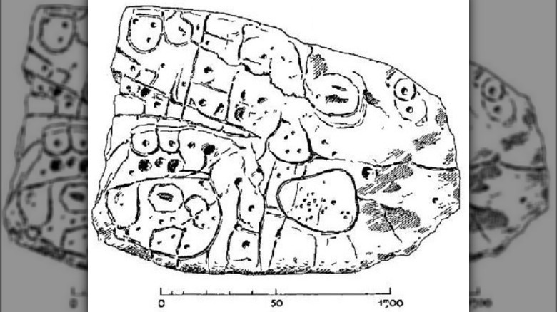
According to Ancient Origins, the Saint-Bélec slab was unearthed in 1900 in the region known as Brittany in France. A man named Paul du Chatellier was conducting an excavation when he came across this broken slab of stone in a grave mound from the Bronze Age. Following its discovery, the map was moved to a private collection before getting picked up by the Museum of National Archeology two decades later. It was not thought about for another 60 years.
In the 1990's, the slab was placed at the home of Mr. du Chatellier, where it again lay undisturbed until 2014. Until that point, the historical artifact had essentially vanished. It wasn't until three years later that the slab was truly examined by a research team. Following multiple tests and extensive study by archeologists, the true value of this stone tablet was finally revealed (per All That's Interesting).
Europe's Oldest Map

Though at first glance it appears to simply be a complexly carved rock that looks like gibberish to the average person, the Saint-Bélec slab turned out to be so much more. According to Science News, the slab dates back to between A.D. 2150 and 1600, making it around 4,000 years old. At this age, this would make this map the oldest map of a known area in Europe. It is also believed to have been used as part of the reburial of Saint Bélec during the Bronze Age.
In addition to the impressive age of the slab, it also contains many features that are consistent with other ancient maps. The map itself is actually 3D, presenting different lines and bumps to represent rivers and mountains (per Science News). A territory near the River Odet is what appears to be depicted by this map. Though its exact purpose remains a mystery, the possibilities include "managing the territory and designating control of the land," according to scientists.