Is Long Island Actually An Island?

You'd think it'd be easy to determine when a landmass is or isn't an island. Here's a simple, multistep process: 1) Stand on land, 2) Look around, and 3) If you're surrounded by water, you're on an island. Some islands are big, like Greenland, the world's largest non-continental landmass. Some islands are miniscule, like the recently volcanically-formed Surtsey south of Iceland. Some are a part of archipelagoes like the Maldives. But when you figure that even whole continents like North America are technically surrounded by water on all sides — as is every landmass on Earth — you can see how even seemingly simple definitions can get tricky. And when common sense abuts legal precedent, all bets are off.
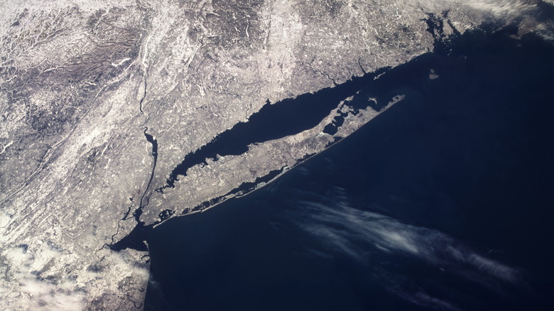
Such is the case with Long Island, a case that exemplifies the weird entanglement of legal necessities and everyday reality. Long Island passes our island test because it's surrounded by water, and you can only access it via bridges from Midtown, Harlem, and the Bronx. So yes, it's an island. But does the U.S. Supreme Court consider it an island? No, as the 1985 United States v. Maine case explains (per Justia). We'll save you a long and technical read by telling you that the court ruled Long Island to be a peninsula and extension of the New York mainland. They did this to prevent disputes over who owns the surrounding water, as an island would technically be in "open sea" and fall under federal jurisdiction — not state.
Contested waters
To be fair, the whole "Long Island is not an island despite being an island" thing came about for rational reasons. As the 1985 United States v. Maine case reads, the Supreme Court had to get ridiculously specific about which areas of water belonged to which state. Block Island and the Block Island Sound seemed to be particular sticking points, as they more or less occupy the intersection of New York, Connecticut, and Rhode Island — if you draw lines out from their coasts.
Just to illustrate how detailed the Supreme Court got, here's its (i.e., the United States') position: "The coast of the State of Rhode Island, except as to Block Island, is the ordinary low water line along the mainland beginning at the Massachusetts border to a point off Sakonnet Point, then a straight closing line across Narragansett Bay to Point Judith, then the ordinary low water line along the mainland to the Connecticut border. As to Block Island, the coast of the State of Rhode Island is the ordinary low water line around Block Island."
Demarcating what water belongs to which state also related to boat licensing and a dispute between Connecticut and Rhode Island. Specifically, Rhode Island heavy-handedly required every registered "foreign vessel and every American vessel" that passed through Block Island Sound to have a pilot on board dispatched from the Rhode Island State Pilotage Commission — an organization designed to keep boaters navigating correctly.
A peninsula, not an island

The Supreme Court's solution to all this gobbledygook necessitated getting down to nitty-gritties of basic English vocabulary like "bay" to define who had what jurisdiction over Long Island's surrounding waters. The United States vs. Maine decision reads that a bay is "a well-marked indentation whose penetration is in such proportion to the width of its mouth as to contain landlocked waters and constitute more than a mere curvature of the coast." Long Island's coast, it continues, is "no more than a 'mere curvature,'" without which "the waters of the Sounds would not be sufficiently surrounded by land so as to be landlocked; neither would they satisfy the semicircle test."
And so, the Supreme Court ruled that Long Island was an "extension of the mainland," citing maritime definitions laid out in 1962's "Shore and Sea Boundaries," published by the U.S. Department of Commerce. The two-volume, 420-page book was written specifically to aggregate existing information about the U.S. coastline to settle "boundary disputes." There is a long way to go to reach what the Supreme Court called a "common-sense approach," but it was apparently necessary to squash interstate squabbling.
In the end, the Supreme Court ruled that Long Island Sound and all of Long Island's various north and south bays fall under the definition of "internal waters," and the island itself is connected to New York. Anything east of the line from Montauk Point (pictured above) to Watch Hill Point is considered "territorial waters and high seas."