The Biggest Stone Henge In The World Isn't Stonehenge
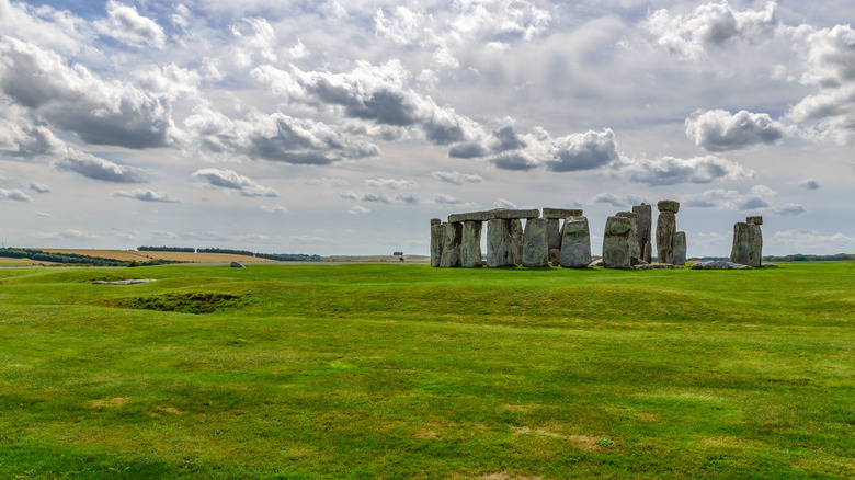
When thinking of neolithic stone henges, most folks would likely think of the big, globally-known one: Stonehenge in Salisbury, England, southwest of London. As The British Museum outlines, the landmark began humbly as a gathering of raised wooden totem poles for hunter-gatherers around 7,000 B.C.E. The site's 25-ton sarsen stones didn't show up until 4,000 years later in 3000 B.C.E., and by 1500 B.C.E. the region had started to fall out of use. During that entire time, Stonehenge was part of a settlement where folks lived, grew crops, worshipped, and so forth. The stone encirclement was also an ancient calendar that tracked solar events like the winter solstice. And while Stonehenge is undeniably an impressive, awe-inspiring site, it's only one of many similar plots.
Back in 1930, British Museum curator Thomas Kendrick used the term "henge" to refer to any number of circular or oval monuments around Germany, France, Ireland, and Britain built using mounds of earth, ditches, and objects like stones and wooden pillars. Ironically enough, this means that Stonehenge isn't actually a henge, because there's no embankment of soil raised around the area. Not only that, but Stonehenge isn't the largest henge of its kind — not by far. Stonehenge is about 330 feet across, while the nearby Durrington Walls are about 1,300 feet across, arguably the biggest known henge in the world (though some point to Marden Henge). The Durrington Walls remain a mystery, but as Stonehenge Stone Circle News and Information says, the plot might have been the residential location for those who erected Stonehenge's sarsen stones.
A sprawling neolithic complex
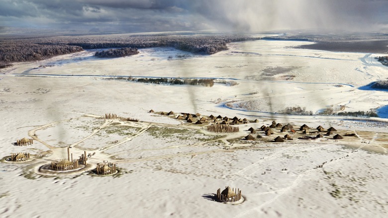
In comparison to Stonehenge, the Durrington Walls are much bigger, much less well-known, and much more recently discovered. Stonehenge was discovered way back in 1620, but the Durrington Walls weren't unearthed until the late 1960s. In fact, aside from ancient maps pointing to a settlement at the site, no one seems to have known it was there. As Stonehenge Stone Circle News and Information describes, a highway — the A345 — was even built right through it. There's also a little village nearby — Durrington — that abuts the northeastern edge of the plot.
It's only recently that researchers have dug deeper into the Durrington Walls. As recently as 2020, Wessex Archaeology described the discovery of a series of shafts dug into the earth around the circumference of the settlement, each shaft measuring about 30 feet across and 15 feet deep. These shafts were likely used for posts to mark the boundary of the site and guide people toward its interior. In 2021, The Guardian says that researchers used a technology called optically stimulated luminescence (OSL) to detect the last time light touched sediment, which dated the pits to 2400 B.C.E. — right around when Stonehenge's sarsen stones were lifted into position. Furthermore, Stonehenge Stone Circle News and Information describes evidence of houses, lanes for travel, and midden pits filled with animal bones from feasting that contain teeth from creatures as far as northeast Scotland some 550 miles away.
A stone's throw from Woodhenge
As Stonehenge Stone Circle News and Information explains, evidence suggests that despite the size and scope of the Durrington Walls, the site might have only been inhabited for a scant 50 years. The settlement's timing (overlapping with Stonehenge's current stone circle) plus its proximity to Stonehenge (a mere 5 miles) has led some to think it was the residential dwelling spot for those undertaking the construction of Stonehenge. On top of this, the Durrington Walls are adjacent to yet another ancient henge: Woodhenge, which was also built around 2500 B.C.E., same as both Stonehenge and the Durrington Walls.
As English Heritage explains, Woodhenge was discovered in 1925 when aerial photography revealed dark spots in the area's wheat field that looked almost like crop circles. Like the Durrington Walls, these spots were holes for posts. Nowadays, those posts have been filled in with logs to show how the ancient site might have looked. In fact, as we can see on Google Maps, Woodhenge is right next to the Durrington Walls, close enough that they look like part of the same complex.
At present, the Durrington Walls, Woodhenge, and Stonehenge are available to visit at any time. The U.K.'s National Trust even has a detailed, 5-mile walking map that guides visitors through each prominent location within and between the sites. For those wishing to embark on a little walkabout and contemplate the lives and mysteries of the past, there might not be a better option.
[Featured image by Ethan Doyle White via Wikimedia Commons | Cropped and scaled | CC BY-SA 4.0]