The World's Most Bizarre Border Splits
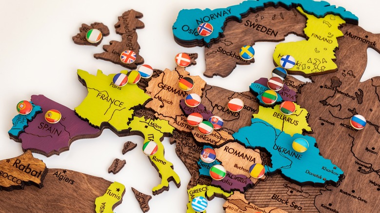
Few things explain the flow of power, politics, war, and the often-arbitrary nature of national identities than a map. Borderlines come from previous borderlines, which came from the mingling and migration of people over thousands of years. Finland didn't exist as an independent nation until 1917, and then it lost a chunk of itself — the maiden's arm — to Russia during World War II. The southern tip of the Netherlands strangely juts between Germany and Belgium and doesn't make sense without knowledge of the Treaty of Maastricht in 1843. Some borders follow natural features like rivers, while others have actual walls. And of course, we all know about the completely bizarre, straight-lined borders of certain African nations that barely overlap with indigenous ethnic groups.
But even bearing all this strangeness in mind, some borders are stranger than others. Some are more "Huh, nifty" than weird. The entirety of the U.S.-Canada border, for instance, is separated by a 20-foot wide gap in the treeline that stretches onward to the horizon (and yes, it requires maintenance). The U.S. also has its Four Corners Monument where New Mexico, Arizona, Colorado, and Utah meet. Esperança, Portugal has a tiny 10-foot-long bridge that connects it to Spain. Belgium and Germany have a bike lane that straddles the line between the countries. But while these are unusual borders, others are truly convoluted — and tell stories far deeper than lines on a map.
One house, one city, two countries
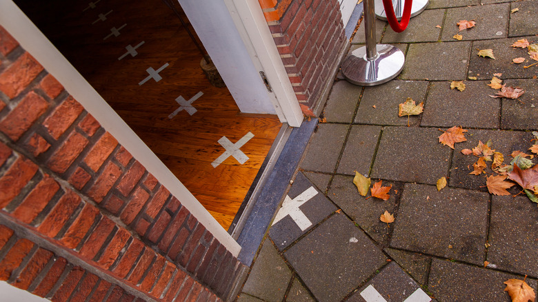
Since we've already mentioned Belgium and the Netherlands, we might as well top our list with what is arguably the most bonkers border situation in the world in the town of Baarle-Nassau. Technically located in the Netherlands near the Belgian border, parts of Baarle-Nassau are in Belgium. As we can see on Google Maps, the Belgian parts of the town cut across blocks at hard-right angles and slice through streets. There are chunks of the same nation separate from each other, and sections of individual houses are even divided by the border of the two countries (pictured above). Heading to the kitchen to grab a snack? You're in Belgium. Heading back to the couch? You're in the Netherlands. It's a good thing that the European Union allows free travel between countries without a passport, otherwise there might be a border guard in the living room.
How in the world did this happen? It all goes back to a nameless, 12th-century Belgian duke who started handing out pieces of land to Dutch counts in the region of Nassau. Fast-forward 800 years and we've got one city with two governments, two legal systems depending on where you're standing, two city councils, overlapping address systems, separate churches, separate civil services like fire departments, you name it. Meanwhile, residents in the same town standing a meter away from each other can reach across an invisible line to shake hands with a person in a different country.
Where Poland, Lithuania, and Russia meet
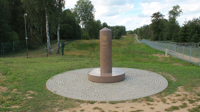
Similar to our last entry — but dashed with a bit of sociopolitical disharmony — we've got the three-way intersection between Poland, Lithuania, and Russia. A granite pole and monument called the Trójstyk Granic marks the spot. And if you stand on it, you're standing right at the point where Poland, Lithuania, and Russia meet — sort of.
Lithuania and Poland are members of the European Union, like Belgium and the Netherlands — folks can walk back and forth between those countries no problem. Russia, however, is very much not in the EU. Strictly speaking, this means that the Trójstyk Granic is in Poland and is not precisely at the point where Poland, Lithuania, and Russia meet. In case it wasn't obvious where the Russian border is, well, the barbed wire fence is a dead giveaway (pictured above). And even though there aren't any guard stations near the Trójstyk Granic, we wouldn't recommend pressing your luck if you visit and poke around the fence too much.
But wait, you say: "Russia doesn't border Poland." True, but only if we're talking about Russia proper located 300-plus miles east of Poland. A fragment of Russia is detached from the country and wedged between Poland and Lithuania beside the Baltic Sea, as Google Maps shows. It's in Russia's Kaliningrad Oblast, formed in 1945, and is legally indistinguishable from any other part of Russia.
[Featured image by Nostrix via Wikimedia Commons | Cropped and scaled | CC BY-SA 4.0 DEED]
Lesotho: a country in a country
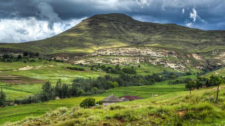
So far we've covered fragmented borders, fragmented countries, and weird intersections. So how about a country within a country? Lots of states have borders stretching along one side or are landlocked and have countries on all sides. But how about a single country encasing an entire other country, with the latter country stuck in the middle like an island? This scenario is made doubly weird because the encased country in question — Lesotho, inside of South Africa — is shaped kind of like an irregular circle, as we can see on Google Maps.
Lesotho's formation, however, isn't that weird and actually makes a lot of sense. To make a very long story short, Lesotho — formerly called Basutoland — was occupied by indigenous tribes at its formation in 1822 before becoming a British colony in 1884. The modern nation of South Africa was formed in 1961, and in 1966 the gorgeous, mountainous Basutoland declared independence and renamed itself Lesotho, accepting the consequences of its odd geographical placement. Interestingly enough, Lesotho's official language is English, and folks do not speak the Dutch-derived language Afrikaans like South Africa, the country that encompasses it.
East Timor: split by Indonesia and the ocean
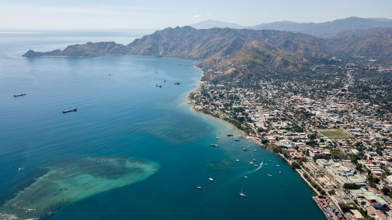
So we come to the strange border situation of Timor-Leste at the easternmost edge of Indonesia's Lesser Sunda Islands. As Google Maps shows, Timor-Leste is split into two halves — east and west — with Indonesia in the middle, all together making up Timor Island. The west part of Timor-Leste is substantially smaller than the east part, and so the entire two-part nation is sometimes called East Timor. This means that worst case scenario, Timor-Leste nationals have no choice but to pass through another country to get to the same country, aka, their own country. To make matters more complicated, there's a conflict between Timor-Leste and Australia to the south about exactly how far Timor-Leste's sovereignty extends into its waters.
Timor-Leste's history explains its strange borderlines. Back in the 16th century Timor Island was ruled by two kingdoms: one in the east, the other in the west. Portugal took the eastern kingdom in 1515, the Dutch the western kingdom in 1651. In 1859 the Dutch and Portuguese agreed on Timor Island's modern east-west borderlines, including Indonesia's composition, but it took until 1945 for Indonesia to gain independence following World War II. At this point, it was integrated with the Dutch Western Timor. Timor-Leste didn't break away as a sovereign, independent nation until 2002. At the time the country adopted the old Dutch-Portuguese east-west borders as its own.
Argentinian island in a Paraguayan river
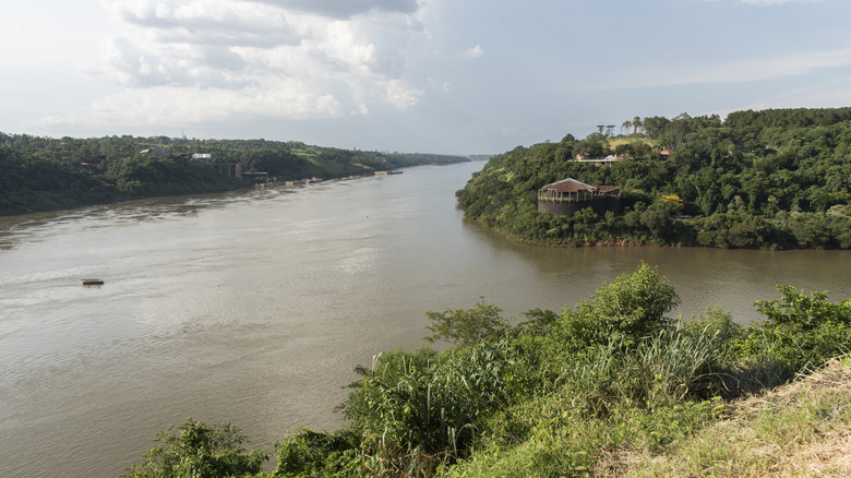
There are many, many more bizarre border splits in the world than what we could cover here. But for now, let's wrap up by circling around to South America and zooming into some little patches of islands along the Paraná River, a river that cuts Argentina from Paraguay and is named after a place in Brazil. Also, the river eventually splits at the place where those three countries meet (pictured above). Specifically, we're talking about Isla Apipé Grande, as Google Maps shows.
Stand on the islands? You're in Argentina. Cross the water to get to another island? You're in Paraguay. Back on an island? You're in Argentina again. The water around the islands belongs to Paraguay, but the islands themselves belong to Argentina. Put differently, the border between Paraguay and Argentina hugs the Argentinian coast whenever an island is present. Otherwise, it runs about midway between the two countries along the rest of the river — at least while water levels are high. Paraguayan water at its narrowest squeezes between Argentinian islands to the southwest of Isla Apipé Grande at a width of no more than around 400 feet.