The Weirdest Things Spotted On Google Earth
It's hard to remember a time before satellite maps. They've been ubiquitous for so many years now, it's weird to think that for a long time, we just didn't know what a lot of stuff looked like from above without expensive aerial photography. Satellite photography could image the entire globe and, over time, would become much cheaper than photos taken from flight.
But when Google Earth (originally known as EarthViewer and used by the CIA) launched in 2001, it was possible to explore the whole world from a brand new angle. As the technology became better and easier to access, regular people started to find more and more unbelievable things.
Some things didn't look the way you'd expect from above. Some things that were previously too remote to be seen by most humans were suddenly a few clicks away. Some people made things specifically to show up on satellite imagery. And a great many of those things are just plain weird.
A huge shipwreck
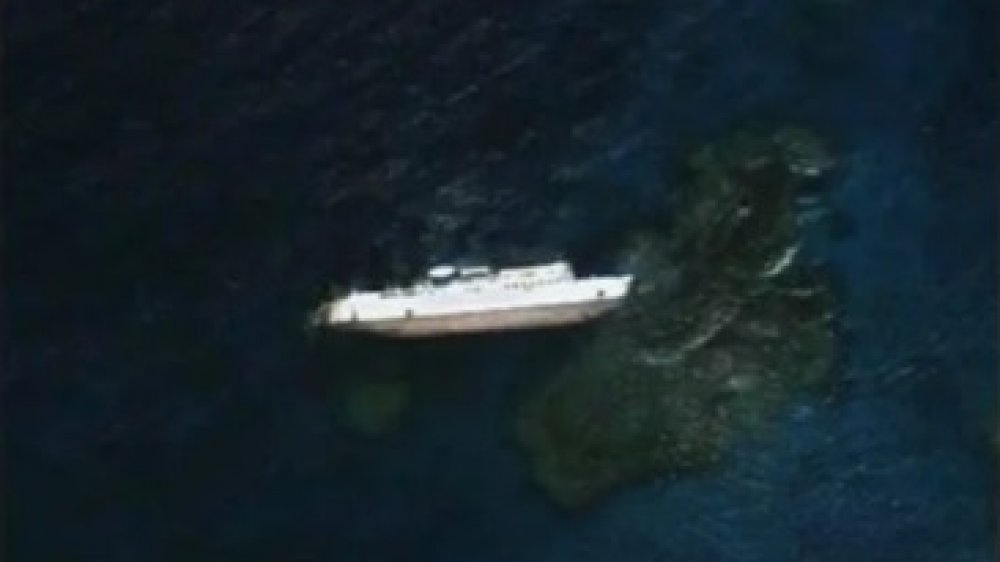
Not only does Google Earth capture images of the ground, but it photographs the oceans as well. Amazingly, you can even under the water a bit, down to a few meters. This means you can see some things like shipwrecks, assuming they happened in relatively shallow waters. This is the case with the S.S. Jassim, a 265 ft. long Bolivian cargo ferry that ran aground in 2003 just off the coast of Sudan, according to Welcome to Earth Dude.
The ship is now notable for being on of the largest shipwrecks visible on Google Earth, according to Time. The S.S. Jassim ran aground on the Wingate Reef and it sank, rotating onto its side near the water's surface. According to The Express, the ship wasn't able to be moved due to issues with the Sudanese government as of early in 2019.
However, looking at Google Earth imagery of the area now, the ship is no longer visible, so it's likely the government was able to go through with their plans to move the ship to deeper waters at some point, though it might be a glitch or photography issue, too. There are still plenty of images of the ship out there as it looked previously, though, so you can still see what the shipwreck looked like.
Strange symbols in the desert
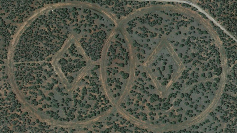
If you flew over Mesa Huerfanita, NM, you might see something strange on the southeastern side. There are two overlapping circles, like a Venn diagram, with diamonds in the center of each. It's almost like a giant, eerie pair of eyes, staring up from the desert. What could it be? A message to aliens? Well, in a manner of speaking, yes.
It turns out it's a marker for a vault run by the Church of Spiritual Technology (CST), according to The Washington Post. And the CST is a branch of the Church of Scientology. The symbols are the CST logo, and weren't widely known about before satellite imagery became commonplace. While the exact purpose of the symbols is unconfirmed, it's assumed they mark the location of a repository of all writings and recordings made by Scientology founder L. Ron Hubbard. The existence of that project has been confirmed by Scientology.
But according to rumors, it's also a doomsday bunker for an inevitable nuclear apocalypse, as reported by LiveScience. In fact, the symbols are allegedly there so future visitors to the planet can see them from above. The facility even has its own private airstrip, just to the south of the symbols.
An eerie symbol in Kazakhstan
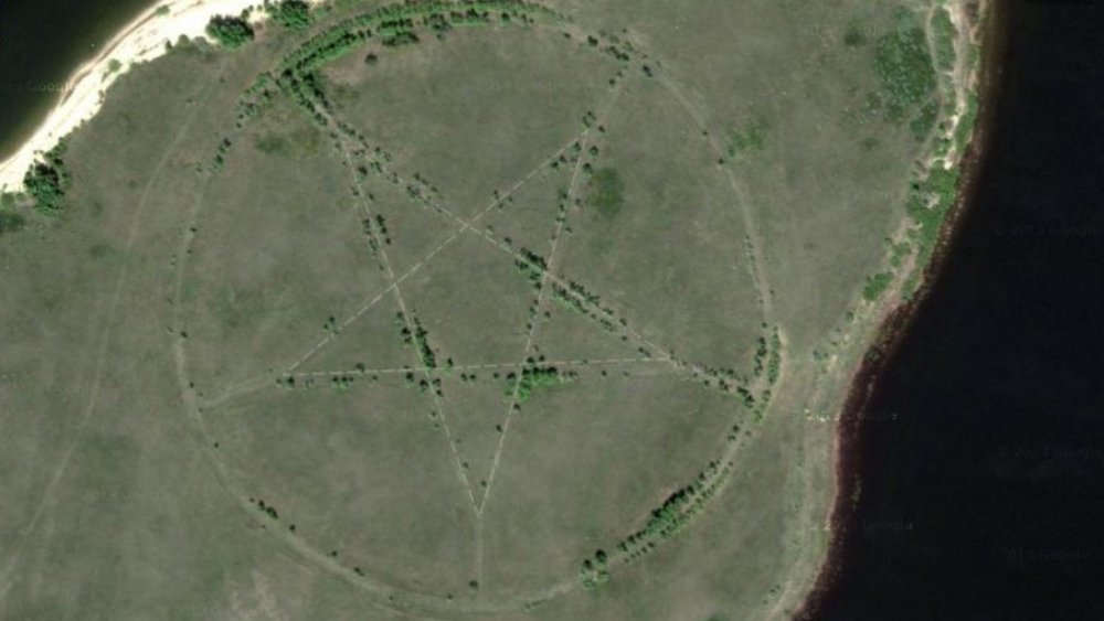
Twelve miles west of the city of Lisakovsk, Kazakhstan is something awfully surprising. What looks like a huge pentagram can be seen with nothing around it. It's very clearly defined, and even has a circle around it, like the traditional depiction of what most people would think of as a "Satanic" pentagram. But Kazakhstan is a majority Islam country, and the pentagram doesn't really have a ton of meaning outside of Western Christian cultures.
So what's this big, creepy sigil doing in the middle of nowhere, Kazakhstan? Did Michael Langdon from American Horror Story set up a base here or something? Not quite! It's actually the remains of a park. Not even a spooky park, just a regular one. So why is it shaped in such a creepy way?
Kazakhstan used to be part of the U.S.S.R., and the Soviets really liked star-shaped things. In fact, a lot of things were star-shaped, and it was a common motif of the time, according to LiveScience. Once the U.S.S.R. fell, the park was abandoned, but the roads and paths are still partially visible from above, hence the eerie pentagram. Just a strange artifact from a bygone era.
A creepy statue in France
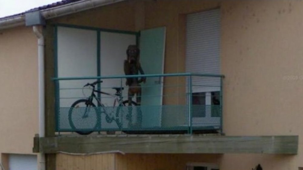
Google Street View opened up a whole new avenue (pun intended) for people to see the world. With human-level views of places around the world thanks to a network of now-iconic cars with camera rigs on top, few streets were out of reach for the internet at large to peek into, finding weird things in neighborhoods and districts all over the world.
One of those weird things was a mummy-like shape on a balcony in Nancy, France. This strange figure looked like a person, but with very thin limbs and a large head with bulging white eyes, standing next to a bike at what looked like an ordinary apartment. The internet went into a frenzy of speculation, declaring it a monster of some kind, and some speculating that it was a gruesome tiki statue, according to Stranger Dimensions. Due to the low resolution of the shot, it wasn't clear just what it was.
And then, shortly after it was discovered, it disappeared. Sort of, anyway. Google hastily covered up the figure with a blurred box, though screenshots of the original photo were still readily available. Why blur out something that's presumably not human, or even living (hopefully)? No one knows. Weirder still, if you check the area on Google Maps as of 2019, the entire building is blurred out. Not suspicious at all.
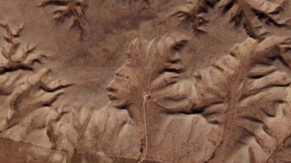
A huge pink bunny in the mountains of Italy
In the Italian region of Piedmont sits the 5,000 foot tall mountain of Colletto Fava, atop which is something bizarre: an enormous, pink rabbit. Or, rather, the remains of one. The rabbit, over 200 feet long, was spotted on Google Earth not long after it launched and it led to questions. Why a pink bunny? Why this particular mountaintop? Did someone make it specifically for Google Earth?
Surprisingly, no. The rabbit began construction before Google Earth was publicly released. A fully knit creation, it was built by a Viennese art collective called Gelitin, according to Amusing Planet. It was completed in 2005, but was actually started five years earlier. The rabbit, simply called Rabbit, was just meant to be a large and unexpected stuffed animal in the middle of nowhere, an art piece. What's more, some details weren't well-captured by Google Earth, such as a creepy strand of entrails coming from the rabbit's side and a horrified expression on its face.
While the rabbit was initially pink, time and weather slowly turned it gray. Since Rabbit was made using standard knitting materials, it wasn't built to last, intentionally so. As of 2019, all that remains of the bunny is a vague, long-eared shape. The creation is expected to eventually be completely decayed within a few years, and the artists have no intentions of preserving it.
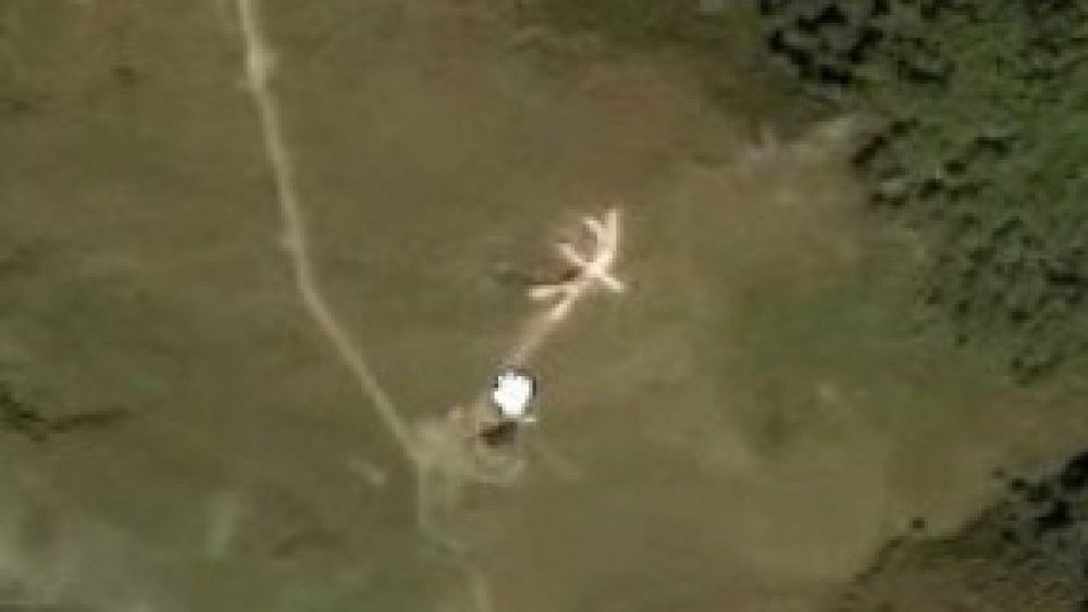
A huge face in rural Canada
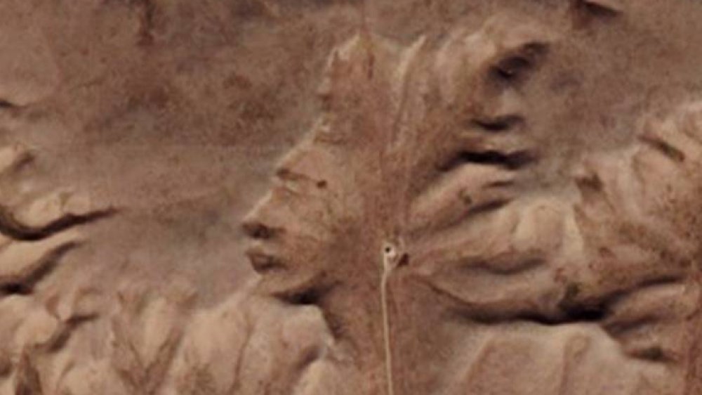
Just a few miles west of the Alberta and Saskatchewan border in Canada is a series of hills and bluffs. There's nothing too wild there, basically just a lot of empty space, a road, and an old well. So, when Google Earth launched and people noticed something odd in the hills, it set off a firestorm of discussion and curiosity.
The hills surrounding the old well look remarkably like a human face, wearing a First Nations headdress. Amusingly enough, some people have also pointed out that the road and well make what appears to be a pair of headphones, like Apple went out and made some advertisement to push AirPods (no wires on your mystery face in the middle of nowhere!) and never told anyone.
Dubbed the Badlands Guardian, according to Atlas Obscura, it turns out the artist behind this very distinct looking face is no one but the weather. The features are all completely natural (minus the well and road headphones) and are due to natural erosion. Now, if you wanted to get spiritual and say that someone or something created the face, then go for it! But as far as science is concerned, it's all just a really neat coincidence mixed with the human tendency to recognize patterns, such as faces, in random things, a phenomenon known as pareidolia.
A red lake in Iraq
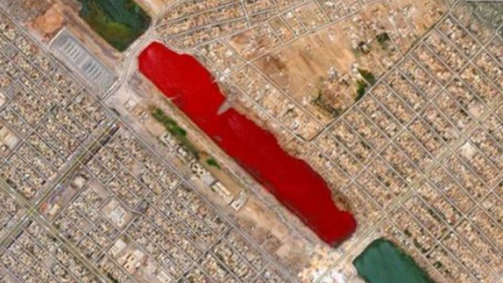
Sometimes, the unusual things found on Google Earth don't really have an explanation. Maybe something normal looks weird for one time period's photos, then goes back to normal later. This is the case with Lago Vermelho in Sadr City, a district of Baghdad, Iraq. While the lake is normally a standard greenish-blue color, for a time in 2007, it appeared as a bright blood red on Google Earth, creating a stir on the internet, according to The Express.
Initial concerns were that it was a glitch, but this was apparently not the case. The lake really was red, but no one was quite sure why. Stranger still, the lake, separated by roadways through the city, is broken up into sections, and only one part seemed to have undergone a creepy change of color. Theories ran wild as to why, from a chemical spill all the way to a particularly gruesome rumor, as reported by Time, that slaughterhouses near the lake had dumped a large amount of animal blood into it.
The actual reason has not come to light so far, but another possibility is something less alarming. Some years later, Lake Urmia in neighboring Iran (about 150 miles away) also went from green to bright red and back again. The reason was because a dry summer caused a red algae bloom in the lake, according to Gizmodo, giving it a similar appearance.
An airplane boneyard in Arizona
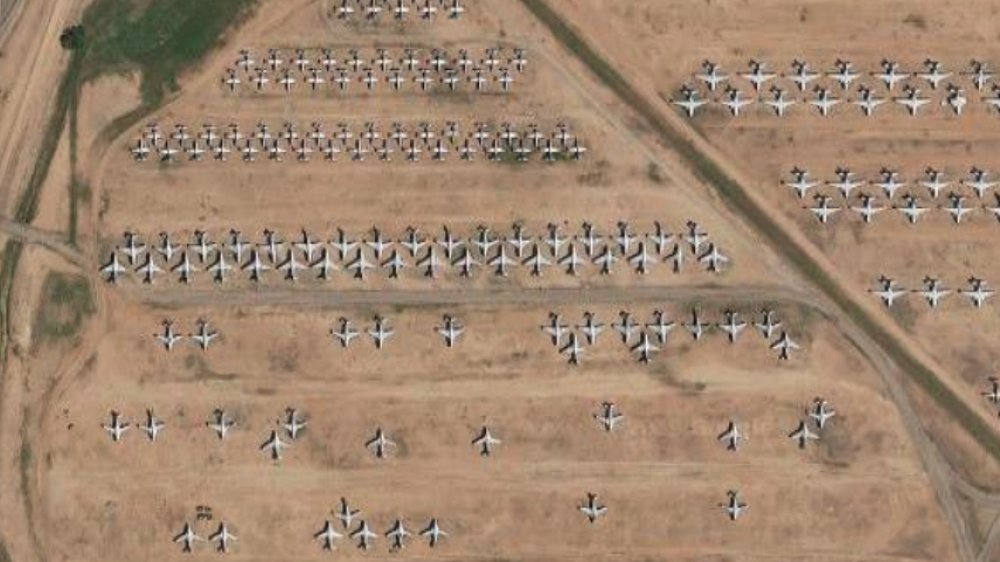
Even fairly normal things can look strange and oddly majestic when seen from the bird's-eye view provided by Google Earth's satellites. For example, near Tucson, Arizona is Davis-Monthan Air Force Base. While it was never a secret that the base was there, what was largely unknown before Google Earth is that it contains one of the biggest aircraft boneyards in the world.
When planes are no longer flyable, they're not tossed into an ordinary dump. Instead, they end up in a boneyard, where these no longer functioning planes can sit and provide spare parts, or potentially even be repaired and brought back into service. While other boneyards can have dozens or even hundreds of planes, Davis-Monthan holds thousands of them, at least one of almost every military plane since World War II, according to Gizmodo, and from above, it looks strangely beautiful and poignant.
Once Google released high-resolution shots of the base in 2010, people became far more aware of it, leading to the US Air Force pointing out that the boneyard is actually completely open to the public, and you can come get a guided tour if you'd like to see it up close.
A creepy reflection of a New York town
The sleepy town of New Baltimore in upstate New York, only has a few thousand residents. The little town doesn't get much actual traffic, much less digital traffic. So, when Google released Street View images of the area in 2007, it took some time for people to realize that something was not right with the photos.
In a strange error, the Google Street View photos of New Baltimore were decidedly horrifying. The buildings and landscape had a weird, otherworldly color to them, with purple skies and black foliage. Worse still, the photos all had a melted look, leading people to dub the glitch "The Gateway to Hell." Visiting the town in Street View was like entering some horrible underworld, where things are a twisted echo of their normal selves.
Google never commented on the photos, and they were quietly fixed around 2016, so unfortunately (or maybe very fortunately), the hellscape is no longer visible on Google Earth itself. There are videos, however, such as the one above, that will take you on a lovely, bloodcurdling tour of the horrors of this otherworld, complete with eerie music that is all but guaranteed to give you nightmares.
A possible murder in The Netherlands
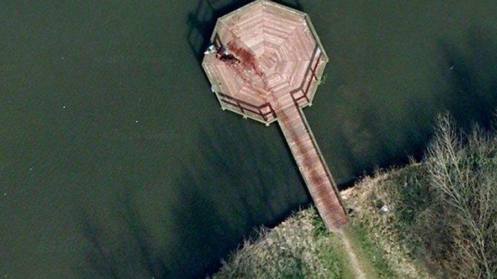
It's common in fiction for a bystander to accidentally capture a murder with their camera. And while a smart criminal might try to do their dirty work in a place far from cameras, what if they were caught on satellite photos? It certainly seemed like this might have happened in The Netherlands in 2009, according to Gizmodo.
The photos show a pedestrian dock in Beatrixpark in the Dutch city of Almere. A long red trail smears across the boards and ends at what looks like a bloody body with a mysterious person standing by. Did Google satellites accidentally capture a picture of a brutal murder in broad daylight?
Probably not. While the photo seriously looks like a murder in progress, the resolution is too low to tell what's actually going on, which seems to be a dog that went for a swim. The red trail isn't blood, but water staining, which appears red due to the color of the wood. The person isn't a killer, but the dog's owner. If you look closely, you can even see what appears to be a ball sitting behind the dog. Since there was no investigation or followups on it, it seems this may have been a case of mistaken identity.
An abandoned island in Japan
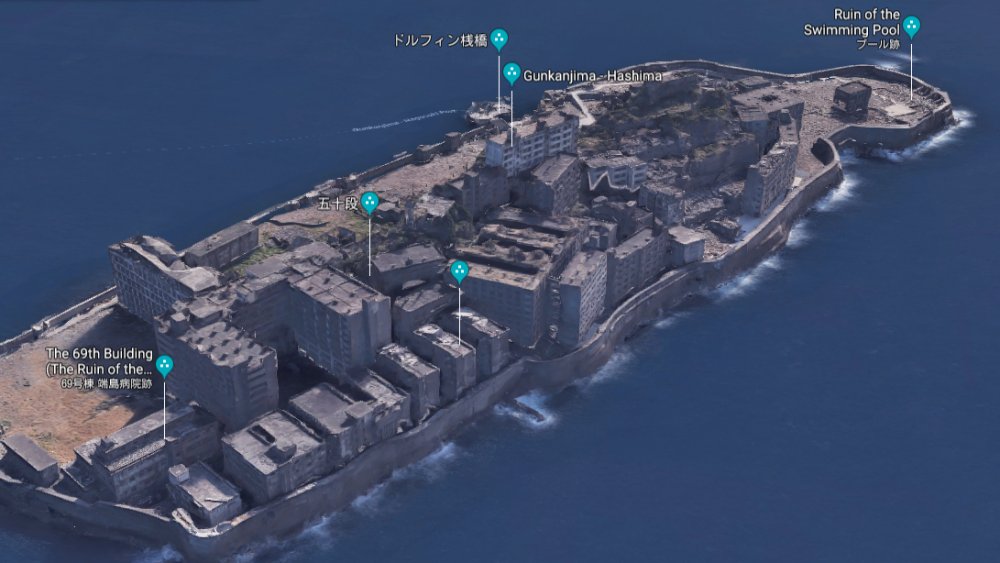
Just under 10 miles off the coast of Nagasaki, Japan is a tiny island called Hashima, which features an old coal mine, the former lifeblood of the island. But in the 1970s, the mine's coal reserves ran out, leading it to close and all of Hashima's residents to abandon it. It stayed that way for over 30 years, until Google Earth came along and virtual tourists rediscovered it.
Since the buildings on the island were built to withstand the sea, they were also more durable in general, so many of them were still standing when curious onlookers began to peek into the island and its history. It still mostly looked like a normal village, albeit with some wear and tear, and so it became a sort of time capsule of post-WW2 Japan.
The island became so popular on Google Earth, in fact, that the Nagasaki government began repairing some of the crumbled walls and reopened the island to tourists in 2009. It was even featured in 2012's James Bond movie, Skyfall. If that weren't enough, to bring things full circle, Google worked with the city government to bring a whole high-definition 3D tour of the island to Google Earth in 2013, according to The Verge.
An otherworldly hot spring in Yellowstone
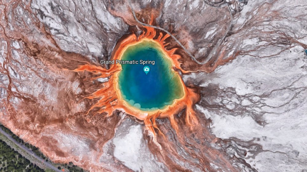
Yellowstone Park in Wyoming is most famous for its geyser, Old Faithful, among with numerous other geothermal features, but none of them is as beautiful as the Grand Prismatic Spring. So named because of the rings of colors surrounding it, the spring is one of the largest in the world, about the size of a football field and ten stories deep, according to Yellowstone Park. It gets its colors from the bacteria that live in the water, with each ring caused by a different form of bacteria that makes its home at that section's particular temperature.
The Grand Prismatic Spring is amazing enough to see from the ground, due to its size and vivid orange, yellow, and green rings, but it wasn't until satellite photography came along that the spring's jaw-dropping features turned out to look almost like an alien landscape from above. It resembles an art piece, like someone deliberately painted the ground or Photoshopped the image to make the spring look like an otherworldly terrain.
It is worth noting that while the Grand Prismatic Spring is open to the public, you really shouldn't swim in it. Even the coolest parts of the spring, the orange ring furthest from the center, is about 130 degrees Fahrenheit, which is likely not a comfortable place for a quick dip on a summer afternoon. The center is even hotter, at nearly boiling temperatures.
A KFC ad near Area 51
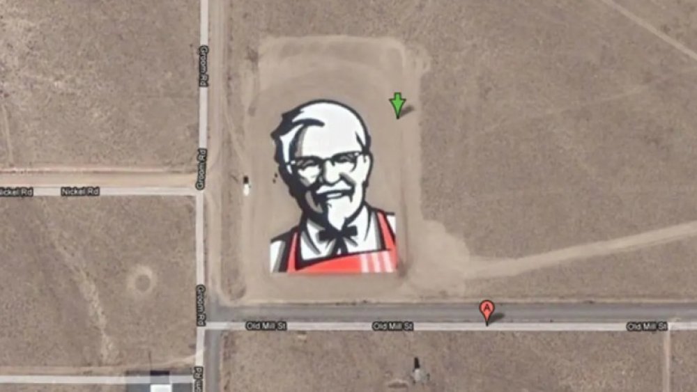
As the world changes, companies have to think about new ways to market and advertise their products, which has led us to a phenomenon called mapvertising. This involves making an ad that can only be seen from above, perfect for viewing on Google Earth. In 2006, Kentucky Fried Chicken decided to be experimental by making a huge picture of Colonel Sanders in a field near where they knew a lot of people would be looking: Area 51.
The Groom Lake area of Nevada is home to Area 51. The base, long speculated to be anything from a place to test experimental aircraft to a storage location for alien technology, is a popular spot for Google Earth viewers since the government denied it even existed for decades. Turns out, there's not a whole lot to see there, just some hangars, runways, and aircraft, but that doesn't stop it from being a constant source of digital traffic.
So, in a field next to the famous Little A'Le'Inn (a popular stop for Area 51 tourists), KFC had their enormous Colonel Sanders looking on for several years. It could even be seen from space, according to Mental Floss. However, in more recent years, it seems that KFC has given up the location, as the field is now sadly Colonel-free.