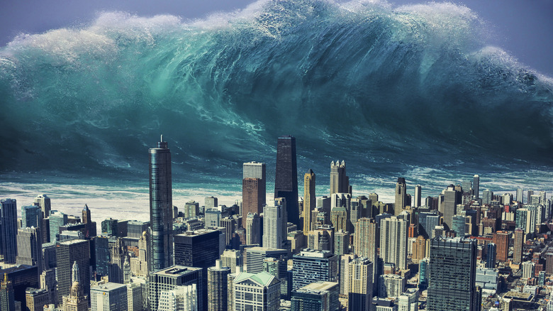
Deadliest Tsunamis Throughout History
In its September 1896 issue, National Geographic Magazine featured a comprehensive story on the destruction wrought by a massive natural hazard that had taken place in Japan three months earlier. It also introduced many readers to a Japanese word that gradually became part of the English language: "tsunami," a combination of the Japanese characters for harbor (tsu) and wave (nami). According to the National Oceanic and Atmospheric Administration's Center for Tsunami Research, an international scientific conference in 1963 helped "tsunami" become a fixture in the global vocabulary for natural hazards.
Today, experts use the word to refer to long, high waves from bodies of water resulting from geological disturbances beneath the ocean surface, such as volcanic eruptions, rockslides or icefalls into water, or earthquakes. While not all tsunamis happen in harbors, it's certainly more accurate than the term it replaced. Prior to the mainstream use of "tsunami," such phenomena were called "tidal waves" — a misnomer, given how these waves have little to do with the gravitational pull of nearby celestial bodies.
As most earthquakes happen near the Ring of Fire, nearly three-fourths of all tsunamis take place in the Pacific Ocean. And every time they happen near populated areas, they serve as a reminder of how much the awesome power of nature dwarfs humanity's own. Here are some of the deadliest tsunamis throughout recorded history.
Ise Bay, Japan (January 18, 1586)
Six years before the end of the Tenshō era, a powerful earthquake with an estimated magnitude of 7.9 to 8.2 shook a number of prefectures in Japan, from the southwestern districts of Osaka and Nara all the way to Shizuoka in the east. According to the National Oceanic and Atmospheric Administration, a Christian missionary described the event as a 40-day disaster that the country had never seen before. Based on the evangelist's record, the tremors caused the collapse of numerous buildings, including temples and fortresses. The missionary also wrote that a great fire "destroyed half the city" of Nagahama in Shiga. Other accounts mention fires in other prefectures, "considerable destruction" in Kyoto, and even a massive landslide at an unspecified location.
The earthquake also brought about a massive wave from Biwa Lake, which reportedly washed out whatever was left of Nagahama. As the missionary wrote: "Not a trace remained of the rich trading city, except for the castle, and even that was underwater." Meanwhile, a tsunami also started from Ise Bay, which reportedly reached a height of nearly 20 feet and crashed into nearby towns (via Australian Geographic). Based on UNESCO's records, the final death toll of the deadly earthquake and tsunami exceeded 8,000.
Ryukyu Islands, Japan (April 24, 1771)
According to the National Oceanic and Atmospheric Administration, 13,486 people died because of the Great Yaeyama Tsunami of 1771. Said to be the result of a magnitude 7.4 earthquake off the southeastern coast of Ishigaki in the Ryukyu archipelago, the tsunami wreaked massive havoc on the islands of Ishigaki and Miyako, with its gigantic waves laying waste to over 3,000 homes in the area (via Australian Geographic). The seismic event was reportedly so strong that even residents of the nearby island of Okinawa felt the tremors (and may even have experienced a smaller tsunami).
The Ryukyu Seismology Lab reports that the waves that hit the southeastern part of Ishigaki reached a staggering height of over 98 feet (though some dispute this). Meanwhile, a 13.1-foot wave hit the northwestern part of Ishigaki, while the islands of Kuroshima and Hateruma were battered by a 16.4-foot tsunami. The islands of Tamara and Miyako found themselves on the receiving end of bigger tsunamis that reached heights of 49.2 feet and 32.8 feet, respectively. Nearly 9,000 people from the Yaeyama islands and 2,000 residents of Miyakojima lost their lives in the aftermath.
Due to the high death toll and how island residents were forced to migrate, population size decreased in the affected areas, even a century after the catastrophe. Making matters worse was a reported increase in plagues and famines, which severely affected livelihoods post-tsunami.
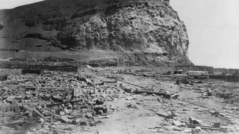
Kyushu Island, Japan (May 21, 1792)
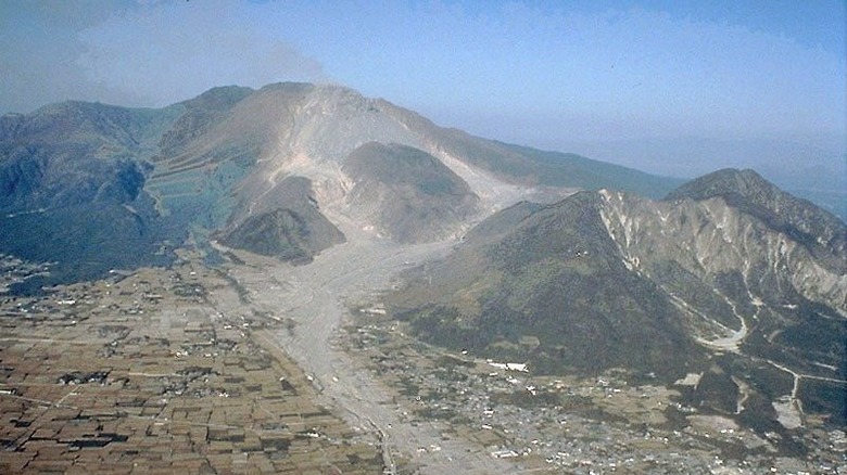
In 1792, an eruption at the Unzen volcano complex on Japan's Kyushu island triggered a series of destructive events that led to the demise of 14,524 people (via the National Oceanic and Atmospheric Administration).
A magnitude 6.4 earthquake followed Mt. Unzen's initial eruption, which in turn set off a landslide from the east side of Mt. Mayuyama, one of the Unzen volcano complex's lava domes. The sudden, massive movement of 4,000-year-old volcanic material devastated the city of Shimabara, causing it to crash right into the Ariake Sea. The sheer force of the volcanic debris generated a massive tsunami that slammed into Shimabara and its nearby areas, causing death and destruction across a 14.2-mile stretch. The property damage and loss of life due to both the landslide and the tsunami made this calamity the worst volcanic disaster in the history of Japan, according to the United States Geological Survey.
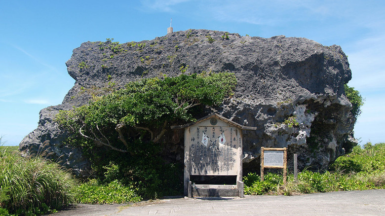
The Unzen Restoration Office explains that the high death toll was largely because of the timing of the catastrophe. The landslide reportedly took place at around 8 PM, "in the moonless dark night," which made it difficult for the residents to fully comprehend the severity of their predicament. It also didn't help that many of them had already returned from the evacuation areas, thinking that the worst was already over. Today, a stone monument called Tsunami-Dome-Ishi indicates the tsunami's height, and the scar left by the landslide on Mt. Mayuyama can still be seen.
North Pacific Coast, Japan (March 11, 2011)
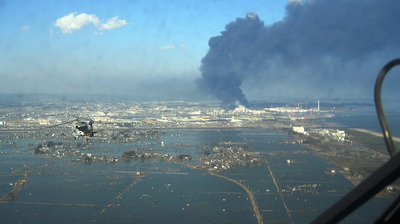
The calamity that hit Japan's Tohoku region on March 11, 2011 is often referred to as a triple disaster, and with good reason. Under ordinary circumstances, just one of the three events involved would be more than enough to cause massive alarm: the fourth-largest earthquake ever recorded, a subsequent tsunami with 100-foot waves, and a meltdown of a nuclear power plant.
The magnitude 9.0 to 9.1 earthquake that triggered the tsunami had its epicenter in the northeast coast of Honshu, at a depth of about 18 miles (via the United States Geological Survey). According to Live Science, the earthquake was the strongest ever recorded in the country. The resulting 32-foot waves reportedly reached nearly 500 mph, forcing over 450,000 residents to relocate to shelters (via Australian Geographic). Unfortunately, all of this seismic activity incurred damage on the infrastructure of the Fukushima Nuclear Power Plant, causing radioactive leaks and core reactor meltdowns.
The National Oceanic and Atmospheric Administration's tally places the final death toll at 18,482. Astonishingly, the effects of the tsunami were strong enough to kill one person in the United States and another in Indonesia (via UNESCO). Brookings estimates that the economic losses reached a total of $360 billion, making the event "the most expensive disaster in human history." (It's worth noting, however, that based on estimated losses, the infamous Chernobyl incident cost nearly twice as much.)
Arica, Chile (August 13, 1868)
According to Australian Geographic, two magnitude 8.5 earthquakes near Arica, Chile (formerly Peru) were the cause of a three-day tsunami event in 1868. Massive waves affected not just the epicenter and the areas near the Peru-Chile coast, but the entirety of the Pacific Rim. The tsunami was so strong that tide gauges in Sydney, Australia managed to capture it.
The earthquakes occurred at 5:30 PM, as stated by eCoast, and they all but destroyed Arica and other parts of southern Peru. Then, at least two gigantic waves followed. A paper presented at the 6th International Symposium on Andean Geodynamics in 2005 revealed that the first tsunami, which crashed down on Arica 52 minutes after the earthquakes, had a maximum height of 39 feet. a second, larger wave emerged from the ocean 73 minutes after the earthquakes, reaching 52 feet in height. The waves killed approximately 25,000 Chileans and Peruvians.
The tsunami then rolled for more than half a day across the Pacific, eventually hitting New Zealand's Chatham Islands and continuing its trail of destruction there (via the New Zealand Herald). Aside from damaging houses, bridges, boats, wharves, and fences near the Banks Peninsula, the waves also wiped out a Maori village, its residents barely managing to escape the wrath of the ocean (via the New Zealand Earthquake Commission). All in all, the earthquakes and tsunami racked up $300 million worth of damage (via Australian Geographic).
Sanriku, Japan (June 15, 1896)
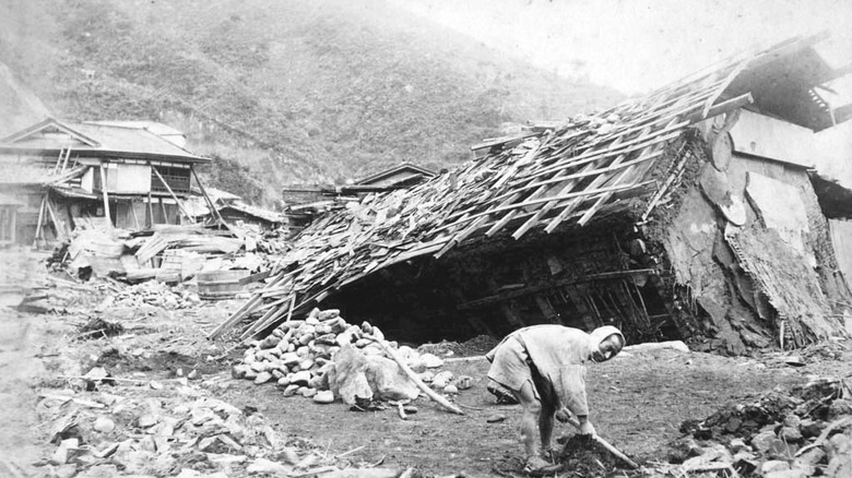
By all appearances, June 15, 1896 seemed like a typical workday for the fishermen of Sanriku, Japan. There was nary a whiff of danger as they fished about 20 miles away from the Sanriku port. According to records cited by the United States Geological Survey, they did not sense anything peculiar in the waters under their boats. But a horrific surprise was waiting for them when they returned to the port. A tsunami had left a 170-mile stretch of coastline completely devastated and over 27,000 people dead (via UNESCO).
The tsunami, which is said to have reached a maximum height of 125.3 feet, was the result of a magnitude 7.6 earthquake whose epicenter was just off the Sanriku coast (via Australian Geographic). The waves flooded and devastated over 11,000 homes, sweeping away houses along the coast almost as soon as they reached the shore.
Interestingly, the effects of this phenomenon were felt in other Pacific areas as well. The June 16, 1896 edition of the San Francisco Chronicle reported a 9.5-foot "tidal wave" in California, while great waves caused the destruction of several wharves and houses in Hawai'i. There are even some reports of a "corresponding tsunami" from China's east coast that flooded local crops and claimed the lives of 4,000 citizens.
Nankaido, Japan (October 28, 1707)
About three centuries before the magnitude 9.0 to 9.1 earthquake that struck Tohoku in 2011, a comparably strong quake hit a different part of Japan — one that, according to the country's recorded history, surpassed everything before it in terms of magnitude. The so-called Hōei earthquake affected Japan's south-central region, ruptured five segments of the Nankai Trough, and may have even triggered the final eruption of the famed Mt. Fuji nearly two months later.
The Weather Network states that the earthquake (which, according to various sources, had an estimated magnitude ranging from 8.4 to 8.7) took place at around 2 PM in Japan. It subsequently generated 82-foot waves that damaged buildings in Osaka and other areas (via Australian Geographic). A 2005 paper by Kyoto University researchers indicated that southwestern Honshu, Shikoku, and southeastern Kyūshū sustained moderate to severe damage because of the disaster. From 3 PM to 4 PM, around 12 tsunamis were said to have crashed into the region. A 1999 paper in Disaster Prevention Research Institute Annuals points to evidence that the Nara Basin experienced liquefaction (the loss of soil strength and stiffness due to earthquakes, which can cause greater damage) as a result of the disaster.
According to UNESCO, at least 30,000 people lost their lives due to the earthquake-tsunami combo.
Enshu-nada Sea, Japan (September 20, 1498)
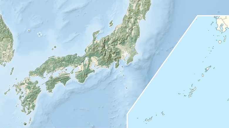
A 2013 paper in AGRIS focused on an earthquake that took place in the latter half of the Meiō era. This earthquake, which reached a magnitude of at least 8.3, generated tsunami waves from the Enshu-nada sea powerful enough to breach low-lying land that separated the sea from Lake Hamana (via Australian Geographic). According to the National Oceanic and Atmospheric Administration, about 31,000 people died, as they and their homes were swept away by the powerful waves.
The calamity ended up having a significant impact on central Japan, both in terms of its geophysical aspects and its societal development. The tsunami reportedly moved a massive amount of sediments to the mouth of the Hamana River in the southern Shizuoka prefecture. This effectively closed the river's mouth, and the lush river environment soon became a marsh. At around the same time, a popular port town called Hashimoto sharply declined, indicating that the tsunami's effects on its environment created a major developmental setback. Eventually, the port town was abandoned, largely due to the fact that it no longer had a direct water route to the Pacific Ocean.
Krakatoa, Indonesia (August 26, 1883)
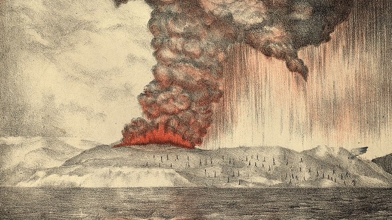
Based on numbers from the National Oceanic and Atmospheric Administration, the 1883 eruption of the Krakatoa (or Krakatau) volcano in Indonesia caused the deaths of at least 34,417 individuals. Live Science describes the event as "one of the most deadly volcanic eruptions of modern history," as it was even powerful enough to affect the global climate two weeks after it took place.
The catastrophe began on August 26, 1883 at 12:53 PM, when "a cloud of gas and debris" shot out from the volcano and traveled roughly 15 miles into the air. Experts theorize that some volcanic material may have fallen into its mouth, effectively blocking the magma chamber and causing a massive pressure buildup. Sure enough, the next day saw four massive eruptions so loud that even people located nearly 3,000 miles away could hear them. The sheer force of the explosion was allegedly almost ten thousand times stronger than the atomic bomb that the United States dropped on Hiroshima.
According to Australian Geographic, it's likely that 2,000 of the recorded casualties were a direct result of the volcanic eruptions. However, it's the resulting tsunamis that truly devastated the population. The 121-foot waves laid waste to two towns: Anjer and Merak. Related events also killed an individual in Sri Lanka, nearly 2,000 miles away. Interestingly, the disaster also brought average global temperatures down by up to 1.2 degrees over the next half-decade, due to the newly-formed layer of gases like sulfur dioxide blocking the sun's light.
Lisbon, Portugal (November 1, 1755)
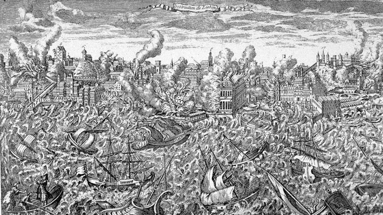
On November 1, 1755, the citizens of Lisbon, Portugal went about their activities just like they would on a typical All Saints' Day holiday. Some attended mass, while others planned for festivities. No one was prepared for the disaster that struck at around 9:30 AM. A magnitude 8.5 earthquake from the bottom of the Atlantic Ocean brought devastation upon the city (via Hakai Magazine).
When the ocean floor's tectonic plates slipped on that day, the energy unleashed was the equivalent of "32,000 Hiroshima bombs." Its effects were felt even in Scotland and Brazil, but Lisbon experienced the worst of it. Three gigantic waves, described by Australian Geographic as up to nearly a hundred feet in height, crashed into the coast of southern Spain and western Portugal. People in Lisbon reportedly heard a "horrible subterranean noise," followed by six minutes of tremors that brought down entire neighborhoods and fires that spread all over the city and raged for five days.
In less than a week, Portugal lost much of its cultural history and architecture, as records, treasures, and structures in the capital city were obliterated by the disaster. Experts say that the final death toll may have reached up to 50,000 across Portugal, Morocco, and Spain (via History.com).
Messina, Italy (December 28, 1908)
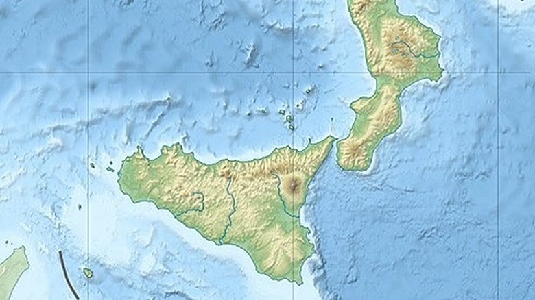
Time recounts the story of the second deadliest tsunami in recorded history: the one that devastated the Italian city of Messina on December 28, 1908, following a magnitude 7.1 to 7.5 earthquake. The event also holds the dubious record of being 20th century Europe's deadliest earthquake (via Temblor).
The waves that struck Italy reportedly reached a maximum height of 40 feet, racking up a death toll of at least 80,000 (and possibly reaching as much as 123,000). According to The Borgen Project, the earthquake and waves also wrecked some coastal towns in Sicily and the Calabria region, and nearly brought down all buildings in the city of Reggio Calabria. Citizens were forced to evacuate the affected towns and cities, with some attempting to flee to New York City via ship. Unfortunately, this resulted in another tragedy in 1909, as the cargo ship Florida collided with the luxury liner Republic in a dense fog, killing three Italians on board (via PBS).
It took more than a century before researchers could figure out which fault generated the destructive earthquake. Using models constructed from existing fault maps, geologists pinpointed the Messina-Taormina fault, an "offshore extensional fault, inclined at 70 degrees towards the east that moved up to 16 ft," as the likeliest source.
Indian Ocean (December 26, 2004)
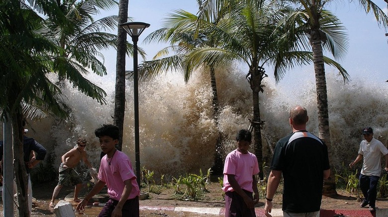
The deadliest tsunami in recorded history claimed the lives of 227,899 people, according to records from the National Oceanic and Atmospheric Administration. The magnitude 9.1 Sumatra-Andaman earthquake took place off the coast of Sumatra, Indonesia, originating from an 808-mile fault zone (via Australian Geographic). The ocean floor reportedly rose by up to 131 feet because of the seismic activity, which released 23,000 Hiroshima-type bombs' worth of energy; this, in turn, created waves that reached a maximum height of 164 feet, which traveled across the Indian Ocean at around the same speed as a jet plane (via World Vision).
It took only about a quarter of an hour before the gigantic waves crashed into the city of Banda Aceh, a densely populated Indonesian city. This left residents and visitors with a tiny window of opportunity to evacuate. As the event happened on the day after Christmas, a number of tourists were there to celebrate the holidays. Similar waves reached India, Sri Lanka, Thailand, and even South Africa, flooding many cities and fishing communities.
All in all, the event lasted for about eight hours, and it was widely documented by tide gauges and eyewitnesses across the planet. The earthquake also affected the planet's rotation by shifting its axis and shortening a day, albeit by a relatively small degree (via the Guardian).