The Oldest Maps In The World
Around the world, it appears as though humans have been creating maps for most of history, if not prehistory as well. While no map will ever be truly exact, since to do so would require a one-to-one scale, many of the oldest maps in the world reflect a similar desire to illustrate one's world.
Some of the world's earliest maps had a functional aspect and were specifically used to assist people in getting from point A to point B. Other maps served a more demonstrative function, seeking to represent the vastness of the known world. But in every map, the human element can be seen through the visual choices of representation and scale. As a result, it's possible not only to see what people thought the world looked like but also how they thought about the world. Depending on what one describes as accuracy, many of the world's earliest maps are remarkably accurate considering that they weren't using the same satellite mapping technology we use today.
Ultimately, even the inclusion of the North and South American continents on maps is comparatively recent, showing that even the vastness of the world depicted on the oldest maps didn't even come close to the reality of the Earth. These are the oldest maps in the world.
Fra Mauro's world map
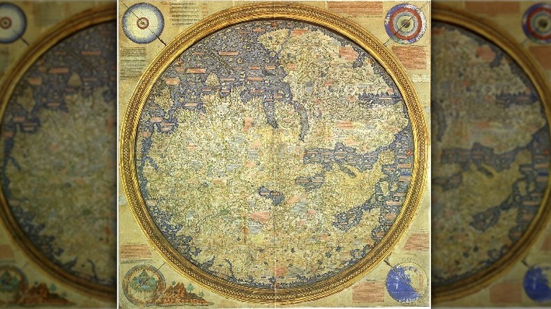
Fra Mauro's hand-drawn map of the world, also known as Il Mappamondo di Fra Mauro, was drawn between 1448 and 1458 and is considered to be one of the first European maps drawn of the known world since the Roman Empire. Although at first glance the map appears to be drawn in the medieval ecclesiastical tradition, it in fact "embodies navigational information from both Mediterranean and Arab seafarers, and like the Catalan Atlas draws heavily on Marco Polo for its concept of Asia," Peter Whitfield writes in "New Found Lands." Mauro also broke with the medieval tradition by moving Jerusalem away from the geographical center of the world, writes Facsimile Finder.
The map includes Africa, Asia, and Europe, as well as the Atlantic and Indian Oceans on the borders. The Garden of Eden is also included on the map, but Mauro locates it outside of the known world, according to "Mapping an Atlantic World, Circa 1500" by Alida C. Metcalf.
The Fra Mauro map is also considered to be significant because it depicted the African continent as navigable, and it most likely encouraged the Portuguese in their quest for colonial undertakings. The Papal bull Pontifex Romanus of 1455 made this clear, as it granted the Portuguese their charter for imperialism by calling it part of a crusade.
Da Ming Hun Yi Tu
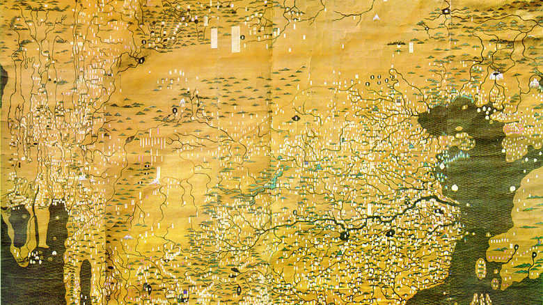
Painted on silk in 1389, the Da Ming Hun Yi Tu, also known as the Amalgamated Map of the Great Ming Dynasty, is considered to be the earliest world map that includes the entire African continent. It is also considered one of the best-preserved and earliest known world maps created in the Chinese language, not to mention the largest, covering an area of almost 200 square feet.
According to "The Dimension of Civilization," edited by Lu Peng, the Da Ming Hun Yi Tu purposefully magnified the land of the Ming dynasty, but because the Cape of Good Hope is depicted accurately, it's believed that the map was influenced by the knowledge of Islamic geographers. The coloring of the map, with rivers and freshwater lakes, painted blue while oceans and saltwater lakes are green, is also consistent with the coloring used on Islamic maps around the time.
In 2002, South Africa was gifted a 1402 Korean reproduction of the map by the People's Republic of China, and the map was used to indicate that there was the possibility of a Chinese presence on the continent before European arrival. However, the depictions of Africa are most likely inspired by Persian astronomer Jamal ad-Din in 1267 or Muslim mariners in 1287. Quartz Africa reports that the repurposing of the Da Ming Hun Yi Tu to signify Sino-African relations was most likely created as an antidote to the growing anxiety about the Chinese presence in South Africa.
Tabula Rogeriana
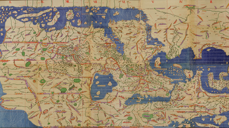
In 1154, Moroccan geographer Abu Abdullah Muhammad al-Idrīsī created a map of Africa and Eurasia for King Roger II Guiscard of Sicily. According to "The Lost White Tribe" by Michael F. Robinson, the Tabula Rogeriana was the most accurate map of Africa for approximately 300 years after its creation.
In making his map, al-Idrīsī followed the tradition of Greek geographer Ptolomy, using geographic coordinates, in addition to incorporating the work of Andalusian astronomer al-Zarqali, writes Gerhard Dohrn-Van Rossum in Al-Idrısı and His World Map. Oriented with the south at the top, following the style of other Islamic maps, the map exaggerates the size of the Arabian peninsula and centers the peninsula, but according to "Science and Technology in World History," it also notably includes relatively accurate depictions of China and Southeast Asia.
Art Storia writes that the large map, painted in color on silk paper and measuring over 6 feet in diameter, is actually made up of 70 smaller maps. There was also a book written to accompany the map, known as "The Pleasure for Those Who Strongly Wish to Travel the Different Regions of the World." According to "A History of Science by Mary Cruse," al-Idrīsī spent 15 years compiling the map. It even contained descriptions of the cultural and political characteristics of different regions.
The oldest surviving Arabic copy, dated 1325, along with the first French translation, can be found at the Bibliothèque nationale de France.
Mahmud al-Kashgari's world map
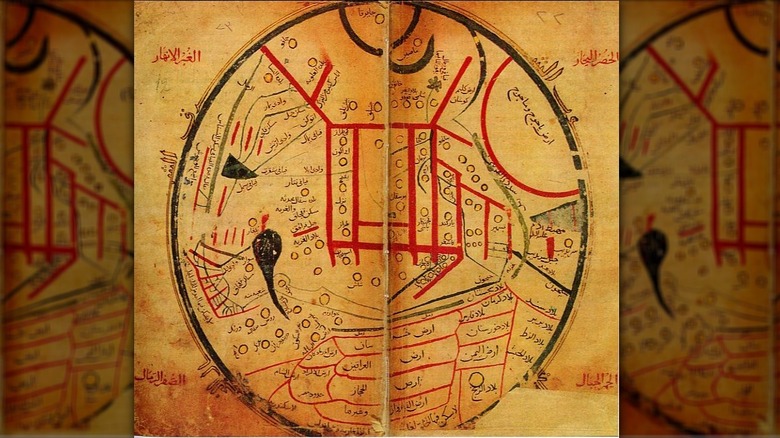
Between 1072 and 1076, Turkic scholar Mahmud ibn Husayn ibn Muhammed al-Kashgari created a circular world map in Kashgar, now modern-day Xinjiang in China. According to "An Anatomy of Chinese" by Perry Link, the orientation of this map deviates from the north/south up positioning — instead east is up, west is down, north is left, and south is right. While it's technically a world map, the plat is centered on Central Asia with other countries receding at the circle border, giving the impression of a fish-eye lens.
According to the Journal of the Ottoman and Turkish Studies Association, the map divides the world into seven inhabited areas, and beyond the seventh inhabitable latitude, it shows the "Land of Darkness," known as Ẓulmāt, going off into the north. Also included is a tower rising out of Alexandria, with a caption that reads, "This is the looking glass that surveys the entire world." The map features an illustration of Japan under the name Jabarqa. As a result, it's believed that al-Kashgari's map is the first world map where Japan is depicted. The next map to show Japan was drawn 400 years later, according to My Old Maps.
My Old Maps also writes that although the map includes many traditional Islamic elements, because of its inclusion as an illustration of Turkish grammar in "Dīwān Lughāt al-Turk," a dictionary of Turkic languages, it is a one of a kind document.
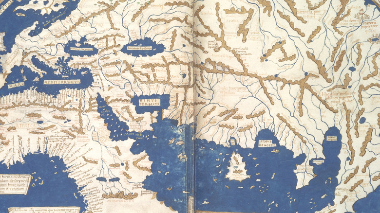
Tabula Peutingeriana
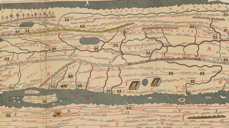
The existing version of the Tabula Peutingeriana is a copy from the 12th or 13th century made by a monk in Colmar, but the original map is dated as far back as the middle of the fourth century. The Roman illustrated map originally showed the vast network of public roads that stretched across the Roman Empire. According to Istria on the Internet, the map includes North Africa, parts of Europe, excluding Spain and the British Isles, and Southwest Asia. The British Isles are believed to have once been included, but they're thought to be on the missing 12th sheet.
In Lighthouses in the Tabula Peutingeriana and their Importance in Late Antiquity, Yvonne Seidel writes that the Tabula Peutingeriana shows the most important traffic routes of the Roman Empire and even includes associated road stations. On the colorful map, the seas and rivers are shown in green while the roads cross by in red. Cities such as Constantinople and Rome are also highlighted, with pictograms showing over 550 cities and 3,500 place names mentioned on the map. "This map was not suitable for navigation, but important ports and lighthouses are recorded, in order to point out their position along the traffic routes," Seidel writes.
Eratosthenes' Map
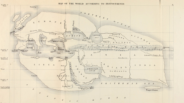
Ancient Greek polymath Eratosthenes was the first to propose a system of latitude and longitude and went on to incorporate them into his world map. Believed to have been drawn in 194 B.C., at the time of its creation it was considered to be the first accurate map of the world, according to "The Ancient World," edited by Frank N. Magill. Sri Lanka Archeology also writes that it's thought to be one of the first maps in which Sri Lanka is depicted.
Eratosthenes reportedly divided the world into what looks like Africa, Europe, Russia, and India, creating a Pangea-like continent in the shape of a parallelogram that's surrounded by an ocean. Eratosthenes was convinced that unfavorable tides were what kept people from sailing around the world rather than the existence of other landmasses. Eratosthenes was also the first to incorporate detailed information in his map based on the knowledge gained during the expedition of Alexander the Great.
Unfortunately, as Nautilus notes, there is no existing copy of Eratosthenes' original map, and it is thought to have been burned in the fire of the Library of Alexandria. But in the first century B.C., the Roman geographer Strabo created a map himself based on Eratosthenes'. Strabo strove for such accuracy to the original that, "He quoted at length from Eratosthenes' text, including detailed descriptions of the original rendering, so historians today have a pretty good idea of what Eratosthenes' map probably contained."
Hecataeus' Map
In 500 B.C., Milesian historian Hecataeus wrote what's considered to be the first thesis on the geography of the world complete with a map. Although the map is lost, the fragments of the text that remain show how Hecataeus actually built his map on the geography of Greek philosopher Anaximander, who is also considered to be one of the first mapmakers and whose map is also, unfortunately, lost. Some even debate as to whether or not Hecataeus was a direct pupil of Anaximander or if he was just inspired by his work.
But despite being lost, the surviving fragments that describe Hecataeus' Map reveal it to be an astonishing piece. According to "Textual Rivals" by David Branscome, Hecataeus based his map on the descriptions of sailors' voyages. It's believed that the map was circular and also depicted the continents of Africa, Asia, and Europe as being surrounded by oceans. It's also noted that Hecataeus was one of the first cartographers to divide the world into continents, according to "A Companion to Science, Technology, and Medicine in Ancient Greece and Rome."
Encyclopedia Iranica writes that Hecataeus' map may have been engraved on a bronze tablet, and may have been gifted to King Cleomenes of Sparta by Aristagoras in an attempt to convince the king to attack Asia.
Imago Mundi
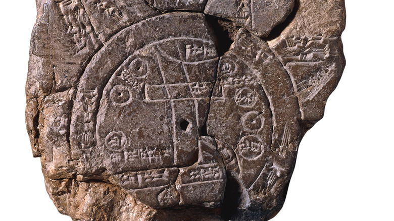
The Imago Mundi, also known as the Babylonian Map of the World, believed to have been carved between 700 and 500 B.C., is thought to be one of the oldest world maps in existence. Jerry Brotton writes in "A History of the World in Twelve Maps" that the Imago Mundi is also considered to be, "the earliest surviving object that represents the whole world in plan from a bird's-eye view."
But the ideas depicted in it are believed to be even older than that. According to "A History of Science in World Cultures" by Alok Kumar and Scott L. Montgomery, the clay tablet that depicts the Imago Mundi is based on a map from the first Babylonian period, which lasted from 1800 to 1100 B.C.
Geography Realm writes that the map placed the city of Babylon at the center surrounded by seven cities and seven islands, which are themselves surrounded by two circles that represent water. Cuneiform writing is also used to label the locations such as the salty ocean that is referred to as bitter.
The tablet was first discovered in the late 19th century in Sippar, Iraq, and was first translated in 1889. Although the map does depict places in their approximate positions, the purpose of the map was also to illustrate the world of Babylonian mythology.
Turin Papyrus Map
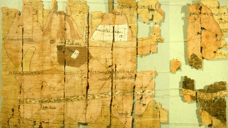
Estimated to be over 3,000 years old, the Turin Papyrus Map may be one of the earliest surviving geographic maps in the entire world. According to The University of Toledo, the Turin Papyrus Map is also notable for being the only topographic map of Ancient Egypt.
Showing a stretch of Wadi Hammamat in the Eastern Desert of Egypt along with the source of the Nile at the top, the map doesn't actually use a consistent scale throughout but varies between 150 and 330 feet for each 0.4 inch. Depicting a quarry for bekhen stone, which History Today writes was used to carve the statues of gods and pharaohs, the map was drawn by Amennakhte around 1150 B.C. after King Ramses IV ordered an expedition of people to the quarry. In addition to being topographic, the map also shows the geographic distribution of different rock types, making it the oldest geologic map in the world as well. The next geologic map would not be created for 2,900 years, this time in France.
Smithsonian Magazine writes that when the papyrus was first found, it was broken into three separate pieces, but the fragments were subsequently pieced together. They can be seen at the Museo Egizio in Turin, Italy, which is where the papyrus gets its name despite being originally from Egypt.
Mammoth tusk
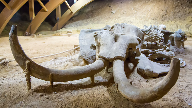
In 1962, a mammoth tusk was found in Pavlov, Czech Republic, but it wasn't an ordinary mammoth tusk. National Geographic writes that with its engravings, this mammoth tusk is believed to be one of the oldest maps ever discovered, dating back roughly 25,000 years ago.
According to "The Map and the Territory," edited by Shyam Wuppuluri and Francisco Dória, the mammoth tusk map depicts a representation of a mountain, a river, valleys, and trails around Pavlov. The Archeological Institute of America also notes that although the Dyje River and Pálava are depicted using abstract patterns and symbols, they may have had metaphorical meaning for the hunter-gatherers who lived in the region.
However, according to "Making Scenes," edited by April Nowell and Iain Davidson, much of this interpretation is speculative because the map requires a great deal of interpretation. Although it's possible to identify rivers and mountains, the authors note the map does not seem to depict a specific area, at least none that is recognizable today. This doesn't mean that it's unlikely that prehistoric people created maps. In fact, it's possible that we may not recognize their maps as maps. This identification of an abstract depiction carved on a mammoth tusk as the oldest known map remains relatively uncertain.
Australian Songlines
Not all maps are necessarily drawn or written down as is demonstrated by the songlines created by the First Nations People of Australia. According to Common Ground, songlines have been in use for over 60,000 years, and by tracing astronomy and geographical elements, they chart the landscape of Australia. The routes illustrated in the songlines are now modern highways and roads that traverse Australia. "The famous route across the Nullarbor between Perth and Adelaide came from songlines, as did the highway between the Kimberleys and Darwin," according to Common Ground.
Also referred to as navigational tracks, the songlines are passed down by elders through an oral tradition and are weaved into creation stories and stories about social law, ABC reports. The songlines of the Seven Sisters are considered to be the most comprehensive navigational tracks and are located across Australia from the west to the east. Because it crosses through the lands of so many different people, the songlines are known by many indigenous people of Australia including the Martu, the Anangu, Pitjantjatjara, Yankunytjatjara, and Ngaanyatjarra.