What Those Symbols On Babylonian Map Of The World Really Mean
A map reveals as much about how its makers saw their world as it does about the physical reality it represents. As Jerry Brotton, Renaissance studies professor at Queen Mary University of London, put it in The Atlantic, "All cultures have always believed that the map they valorize is real and true and objective and transparent," but, "All maps are always subjective." One example is the so-called Babylonian Map of the World.
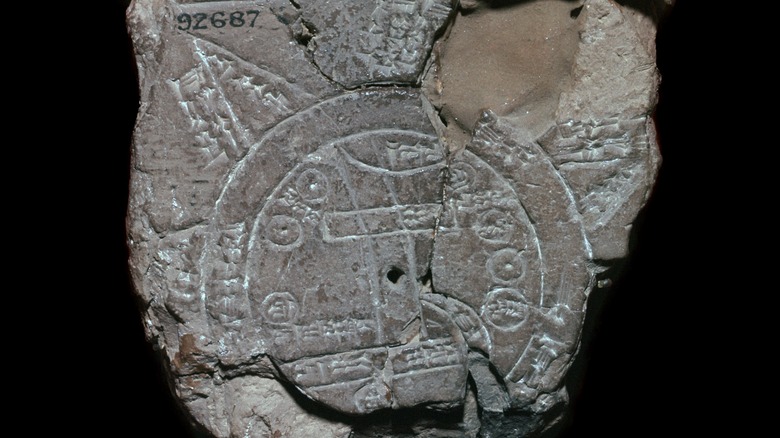
The Babylonian Map of the World was first drawn around the ninth century B.C., according to CNX. However, the version that has survived was likely copied onto a tablet around the sixth century B.C. The tablet was found in Sippar, Iraq and was acquired by the British Museum in 1882, the museum said. The map is accompanied by text both above the image and on the other side of the tablet, according to CNX. The map itself represents the world as two circles, one inside the other. The outside circle represents a body of water referred to as the "bitter river," according to the British Museum, and the "salt sea," according to CNX.
Center of the world
The map's inner circle shows the Euphrates River flowing from north to south through its center, according to the British Museum. The river emerges from a figure labeled as a mountain, which probably represents its source in the mountains of southeastern Turkey, according to CNX. It then ends in an area labeled swamp, which likely represents the marsh that used to thrive along the southern Euphrates in ancient times. From the swamp, a channel runs to the left, which might represent a canal to the Persian Gulf.
The city of Babylon is represented as a rectangle near the center of the map. While the ancient city is placed to the right of the Euphrates on the map, it actually occupied both sides of the river, according to the British Museum. Placing Babylon near the center of the map reflected the mythology of the day, according to CNX. In the Enuma Elish, the Babylonian creation epic, Babylon was both the capital of the world and located at the center of the world. The fact that Babylon is a rectangle could represent the walls of the city, but it also ties in with the myth that Marduk, the king of the universe, founded Babylon by laying the first brick.
Circular cities
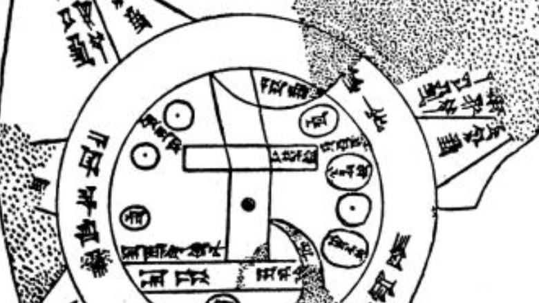
Babylon is not the only city depicted in the map. Eight other cities are represented on the map as circles, according to CNX. Three of them are labeled Assyria, Der, and Susa. Two others are simply labeled city, while the remaining three have no labels at all. The text at the top of the map mentions ruined cities, which is possibly what the unnamed cities represent. The cities are not drawn to scale, because they are all shown to be the same size. It's possible that circles were chosen to represent them because over time, many cities in ancient Mesopotamia formed rounded, raised mounds, called tells.
The inner circle of the map also labels three regions with no corresponding symbols: Urartu, Bit Yakin, and Habban. Bit Yakin was the territory of an Aramaean tribe that lived near the southern Euphrates and is located near the channel on the map, according to the British Museum. The independent kingdom of Urartu is located relatively accurately in northern Assyria. However, Habban is placed inaccurately to the west of Babylon. In reality, this territory of a Kassite tribe was located in western Iran.
Outer regions
Emerging from the outer circle are four triangles that represent outlying regions, according to CNX. The accompanying text indicates that there were eight in total, but their image has not been preserved. The text on the back of the tablet describes each of the eight regions, but much of it has been lost, according to the British Museum. However, what survives indicates that they were inhabited by heroes and fantastical creatures, according to World History Encyclopedia. "Their interior no one knows," the description reads, according to the British Museum. The map labels the distance between the regions as either six or seven beru, a Babylonian measurement of both time and distance. The text, on the other hand, gives the distance as seven beru.
The outer regions are labeled as nagu. While this literally means region, it also might have a mythological significance. In the Babylonian flood myth recounted in the "Epic of Gilgamesh," nagu are described emerging from the receding flood waters. The triangular shape on the map along with the fact that the nagu were the first land masses to emerge from the flood could mean they are intended to be understood as mountains. The triangular shape also represents how a new land mass would appear when approached from the ocean, according to World History Encyclopedia. While the map represents the physical Babylonian world relatively accurately, its primary motive is to illustrate the mythology that united it spiritually.