Barometric Pressure In Hurricanes Explained
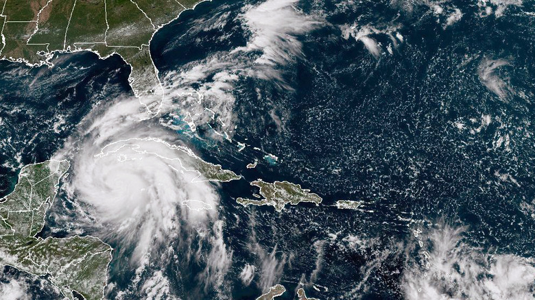
While lower blood pressure may be good for your health, low barometric pressure over the ocean is not a good sign. According to the National Weather Service, the United States measures pressure in "inches of mercury" and "millibars." Inches of mercury measurements are typically what you hear your local news anchor discussing when they attempt to predict the weather. At sea level, standard air pressure in this unit should be around 29.92, or 1013.25 millibars. The Southeast Coastal Ocean Observing Regional Association states that a low-threat hurricane's barometric pressure drops to about 28.94 inches of mercury (980 millibars), and an extreme Category 4 hurricane drops to 27.17 to 27.88 inches of mercury (920 to 944 millibars). As of press time, September 2022's Hurricane Ian — which was on course to touch down in Tampa and Fort Myers, Florida — was considered a Major Category 3 Hurricane, on the cusp of Category 4, with sustained winds of 120 mph at a pressure of 947 millibars (via National Hurricane Center).
Notable storms with extremely low barometric pressure include 2005's Hurricane Wilma, which reached 882 millibars, the lowest barometric pressure ever recorded in the Atlantic Basin (via Rhino Steel). Other infamous hurricanes with low barometric pressure include Hurricane Katrina, which was registered at 920 millibars at landfall on the Gulf Coast in 2005. Florida's biggest impact occurred with Hurricane Andrew in 1992, with a low-pressure reading of 922 millibars, making landfall as a Category 5 storm.
Cyclones (sometimes called "typhoons") and hurricanes are a ferocious mix of strong winds and rain coming into contact with the ocean's surface (via Britannica). Winds are attracted to low barometric pressure areas and begin to swirl because of atmospheric dynamics — layers of the atmosphere such as the stratosphere and troposphere experience an increase in exchange (via the Department of Atmospheric Sciences at University of Washington).
Jetsetting
Jet streams are an important driver of storm direction. Storms originate in the Atlantic Basin between Africa and the Leeward Islands or in the Caribbean and Gulf of Mexico basin, while the subtropical jet stream carries them from east to west (via National Hurricane Center). However, to the American weather audience, the polar jet stream is what is commonly observed by meteorologists. A dip of the polar front jet stream, for instance, creates cold fronts of high pressure in North America (via Britannica). At the interface between the high and cold areas of pressure is where thunderstorms, tornados, and lightning occur due to high atmospheric mixing and energy transfer.
Typically, the Earth's polar jet stream, which is located in the troposphere, is about 5 to 7 miles above the surface of the earth, and winds blow from west to east (via MetOffice.uk.gov). When storms leave the incubator from the subtropical jet stream, they change direction. Because jet streams are not in constant positions, these interactions can be quite chaotic. So what does this have to do with barometric pressure? As long as the storm's barometric pressure and atmospheric shear (a change in wind speed with height) remain low, a hurricane will increase its intensity (via the National Weather Service). High levels of shear from the jet stream can weaken even the strongest of storms.
Unto the breach
Aristotle postulated, "Nature abhors a vacuum." Although some researchers debate this idea in nature, if there is less of something in one area, nature will try to fill in the gap. In terms of air pressure, if there is high pressure in one area, that means there is low pressure in another. So when it comes to weather, we know the lower the barometric pressure, the stronger the storm (via Rhino Steel Building Company).
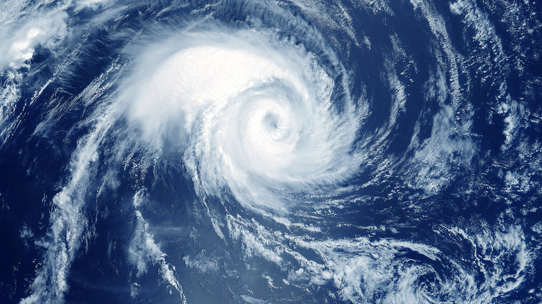
All the while, the Earth is spinning like a top, and all of these layers are free to move as it rotates. This action creates a lot of mixing, and the general motions that occur are due to what is known as the Coriolis effect (via National Geographic). Centrifugal forces and angular momentum interact to drive this effect. As the root of the term centrifugal literally suggests "to flee" from the "center" (via Vocabulary.com), the center of the storm is of the lowest pressure, and the great reaction is to fill the void of the tremendous energy within the cyclone.
The aforementioned jet stream can increase the strength of a low-pressure area and create an eye wall, which sucks air up from the ocean's surface (via NASA). The spinning and swirling effect you see is made up of ocean water and storm clouds. The eye of the storm is the area of the lowest pressure — it is cloud-free in the strongest of storms — while the eyewall has the strongest wind circulation. Hurricanes are divided into quadrants, and the front right quadrant is considered to be the most dangerous, with high winds, strong rainfall, and storm surge (via Action News 5).