The Scary Way Climate Change Is Affecting Earth's Gravity
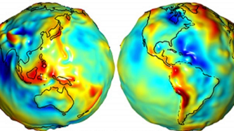
Climate change influences everything from the length of U.S. summers to the amount of rain that falls when it storms (via The Washington Post and the EPA). But, did you know that it also impacts the Earth's gravitational pull? This fact was illustrated by a discovery made by the European Space Agency (ESA) in 2014. The discovery was made possible by the fact that satellites can actually provide an image of Earth's gravitational field. In 2009, the ESA launched the Gravity Field and Steady-State Ocean Circulation Explorer (GOCE) satellite to create the most detailed map to date of Earth's gravity. "The colors in the image represent deviations in height (–100 m to +100 m) from an ideal geoid," the ESA explained to Bloomberg. "The blue shades represent low values and the reds/yellows represent high values." (If you're wondering what the ESA means by geoid, it's a global model of mean sea level used to measure elevation, NOAA explained.)
GOCE was not actually intended to record changes in Earth's gravity, the ESA said. However, the high-resolution measurements it took over Antarctica between November 2009 and June 2012 ended up doing just that. Scientists from the German Geodetic Research Institute, Delft University of Technology in the Netherlands, the Jet Propulsion Lab in the U.S., and the Technical University of Munich in Germany looked at the measurements and noticed a valley in the gravity field over the southernmost continent because of ice loss.
Changing gravity
The reason that melting Antarctic ice can impact Earth's gravitational field is that gravity does not pull equally from every point on the planet. The more mass a given feature has, the stronger a gravitational pull it will exert, NASA explains. This means that heavy materials like granite will have stronger gravity than lighter materials like water. Another factor is density. In a mountain range, for example, heavier materials are all bunched up together on the Earth's surface. This means that satellites will actually speed up while approaching mountains and slow down as they depart, according to MIT Technology Review. This means the Earth's gravitational field, or the three-dimensional map of its gravity, looks more like a piece of popcorn than a marble. "Because the distribution of materials deep inside the Earth varies, its gravity field has hills and valleys," Michael Watkins of NASA's Jet Propulsion Laboratory said.
Earth's gravitational field isn't just bumpy, those bumps are constantly shifting like sand dunes. This is because around 71% of the planet is covered in water, and that water moves with the tides and the seasons. For example, according to the MIT Technology Review, some bodies of water may dry up in the summer or expand in the rainy season. "The Earth's gravity field changes from one month to the next mostly due to the mass of water moving around on the surface," Watkins told NASA.
Ice, water, and gravity
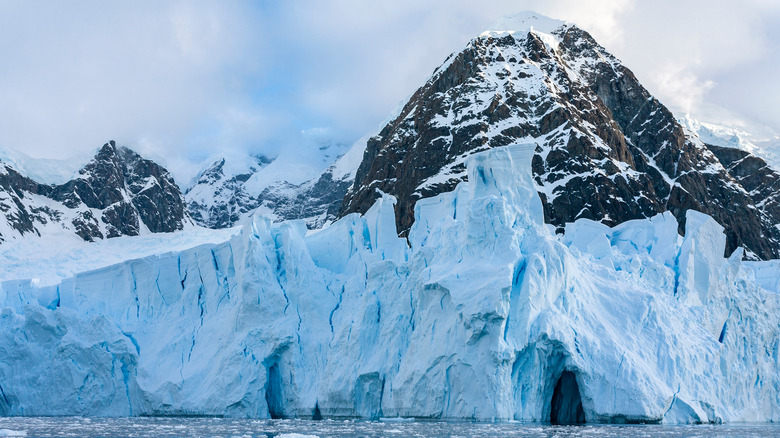
This is where the climate crisis comes in. The climate has warmed by around one degree Celsius since pre-industrial times. This is largely due to human actions like burning fossil fuels which release greenhouse gasses into the atmosphere, according to the Intergovernmental Panel on Climate Change. However, as with gravity, this warming is not even. The poles are warming at a faster rate than the rest of the planet, with Antarctica heating nearly three times faster than the global average, according to Scientific American. This warming is causing Antarctica's glaciers to melt, according to WWF. West Antarctica is especially vulnerable; though East Antarctica's glaciers are retreating too, it's at a much slower rate, according to National Geographic.
When land ice like the West Antarctic glaciers melt, it inevitably changes the Earth's gravitational field because the placement of ice mass and water mass shifts, as an article published in the Netherlands Journal of Geosciences explained. Before ESA's 2014 discovery, scientists had been using different satellites — the NASA–German Grace satellites — to use gravitational changes to measure ice loss, the ESA said. However, the GOCE measurements provided more detailed images and could zero in on the different "catchment basins" that make up the ice sheet. Together, the satellite measurements gave scientists a new understanding of the extent of the Antarctic's melting ice. "They have found that the loss of ice from West Antarctica between 2009 and 2012 caused a dip in the gravity field over the region," ESA wrote.
Understanding climate change
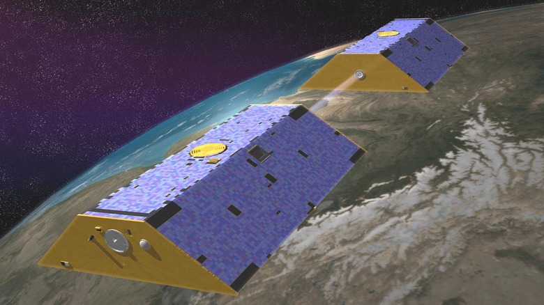
The fact that ice loss shifts Earth's gravitational field can help scientists better understand the impacts of climate change. In 2019, scientists published a study in Nature reviewing all the data from the GRACE satellites. "Since 2002, the Gravity Recovery and Climate Experiment (GRACE) has enabled monitoring of the terrestrial water cycle, ice sheet and glacier mass balance, sea level change, and ocean bottom pressure variations, as well as understanding responses to changes in the global climate system," they wrote. This data provided the first-ever direct measurements, as opposed to estimates, of ice loss from glaciers and ice sheets, according to a press release from GFZ GeoForschungsZentrum Potsdam, Helmholtz Centre. Between 2002 and 2017, Antarctica shed 140 billion tons of ice per year and Greenland lost 260 billion. It also revealed that 60% of the loss was because of melting due to warming temperatures and 40% was from icebergs calving into the ocean.
The melting of polar ice is so concerning because it causes sea levels to rise. The West Antarctic ice sheet, for example, has enough water to raise sea levels by around 3.2 meters (just over 10 feet), according to The Harvard Gazette. The GRACE measurements revealed that 2.5 millimeters of average yearly sea level rise from 2005 to 2017 was because of ice melt and 1.1 millimeters because water expands as it warms. Understanding this ratio is crucial for accurately predicting sea level rise and preparing coastal communities for the future.