Countries With The Highest Risk Of Earthquakes
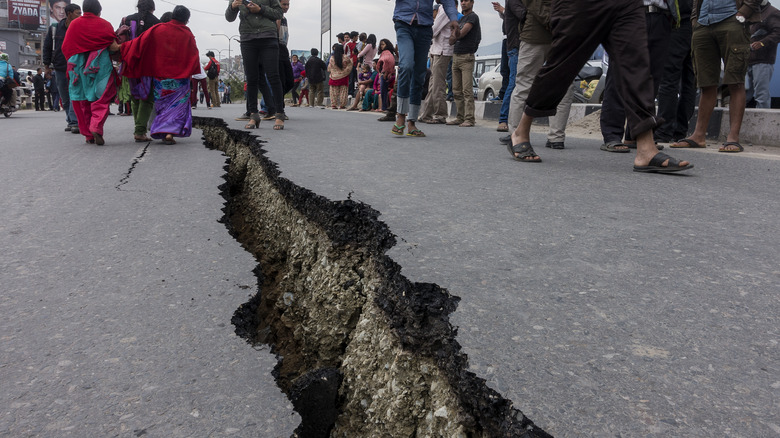
Every year, over half a million earthquakes shake the crust of planet Earth, but most are so faint that no one even notices. According to the USGS, only about a fifth of all earthquakes are strong enough to be felt, and just 100 each year carry enough power to cause any actual damage.
However, while there's nearly always an earthquake happening somewhere in the world, not all parts of the planet's surface are created equally, and some areas are dramatically more active than others. Earth's crust isn't a single solid piece, but a collection of tectonic plates which are slowly but constantly jostling for position. It's the jolts and grinds at the boundaries of these tectonic plates which cause earthquakes and, as National Geographic explains, the most active boundaries encircle the Pacific Ocean. Known as the Ring of Fire, this is where 90% of all earthquakes and 75% of all active volcanoes can be found.
While most earthquakes happen in certain hotspots, however, they can and do occur everywhere. As the British Geological Survey notes, this includes places like the U.K., which are far from any tectonic plate boundaries. The USGS also mentions that there's no straightforward answer to the question of which country has the most earthquakes, but it's possible to look at how frequently countries are affected by them. CRED/UCLouvain in Brussels, Belgium, maintains the EM-DAT database of natural disaster data, which can give an overview of which countries have the highest earthquake risk.
High-risk areas
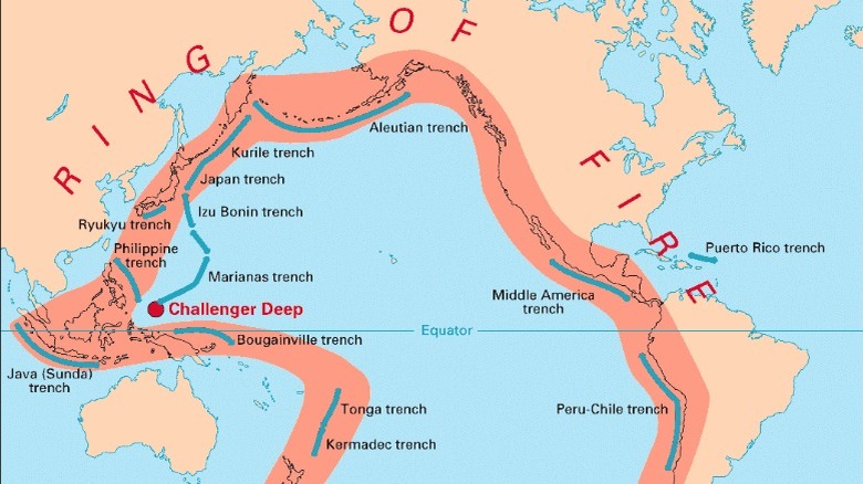
The Ring of Fire is hazardous, even for countries less frequently hit by earthquakes. In fact, it's responsible for the most powerful earthquake ever recorded. As National Geographic explains, the city of Valdivia in Chile was hit by an earthquake in 1960, with a Richter scale magnitude of 9.5, making it the most powerful quake in recorded history. The power of earthquakes is usually assigned a magnitude value, measured using the Richter scale. As How Stuff Works explains, this is a logarithmic scale, meaning that each increasing number corresponds to a tenfold increase in power. While a magnitude 1 earthquake is barely even noticeable, a magnitude 9 quake is 100,000,000 times as strong.
Another geographic region known for earthquakes is the Himalayan Belt. Also known as the Alpide Belt, India's National Disaster Management Authority notes that this tectonic boundary makes over 59% of India prone to earthquakes classified as "moderate to severe." The belt is an orogenic region, which means it's an area where Earth's tectonic plates are pushing together, buckling, and forming mountains. The effects of this can be nothing short of dramatic. As a conference presentation at the American Geophysical Union mentions, it's the tectonic forces in this belt that caused the formation of the Himalayan mountain range as the Indian and Eurasian tectonic plates collided. This tectonic boundary is responsible for earthquakes across South and Central Asia. The largest orogenic belt in the world, it's the reason why Earth's highest mountains exist.
Pakistan and Afghanistan
According to EM-DAT, Pakistan and Afghanistan recorded 35 significant earthquakes each over the past century, and the tremors in both countries stem from the same fault line. As a USGS press release explains, these quakes come from the Chaman fault system, a fault line that stretches over 528 miles (850 km) and lies beneath both countries. A paper in the journal JGR Solid Earth explains that the Chaman fault is caused by interaction between the Indian and Eurasian plates. The resulting forces compress the rock, causing a strike-slip fault – the same effect behind California's infamous San Andreas fault line.
The Chaman fault isn't entirely understood by seismologists, a few things about it still seem to defy explanation. As Nature explains, earthquakes in Afghanistan can cause a surprising amount of damage, even at lower magnitudes. This could potentially be caused by the depth of the earthquakes, but researchers have difficulty studying the area. There are few seismic stations in the area, and issues of safety and security make it difficult for scientists to visit. However, there could be a simpler explanation for the damage. In an interview with Scientific American, seismologist Lucy Jones explains that the damage could simply be because of the kind of construction used in the affected buildings. Some buildings are just more easily damaged.
The United States of America

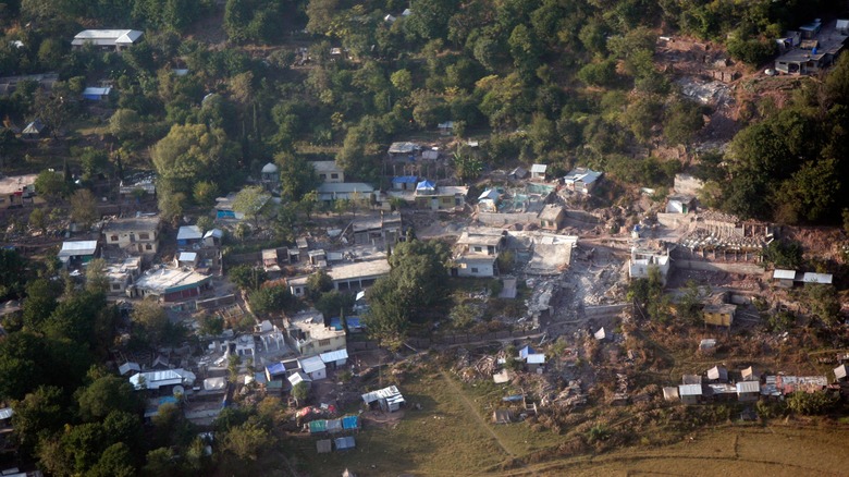
Earthquakes are commonplace in some parts of the U.S., with 38 significant ones being recorded over the last century, according to EM-DAT. While mild tremors are nothing unusual, however, America sometimes sees violent quakes. As Singapore Earth Observatory notes, the second most powerful earthquake ever recorded was in the U.S. With a magnitude of 9.2, it struck Alaska in 1964 (pictured). The cause was a subduction zone – a place where two tectonic plates collide, with one slipping underneath the other. These subduction zones are responsible for many of the world's most powerful earthquakes and, as National Geographic mentions, they make up much of the Ring of Fire.
Because the United States of America spans an entire continent (as well as Alaska and Hawaii), some places are affected by earthquakes much more than others, as Live Science discusses. California is famously earthquake-prone, with most of the USA's quakes being felt there and in Alaska. Because of the Ring of Fire, though, earthquakes can be felt anywhere along the Pacific coast. Inland states are not immune, however, with earthquakes also being recorded in places like Montana and Idaho. States in the American midwest are known for their tremors, which are infrequent but powerful when they happen.
The Philippines
The Philippines is a very geologically active country, experiencing 39 significant earthquakes over the last century, according to EM-DAT. A closer look at the Philippines shows that this is no surprise, however. Tectonic activity, as World Atlas explains, is exactly what caused the Philippine archipelago to form. Over millions of years, the shifting and buckling tectonic plates, and the volcanic eruptions they've caused, have sculpted the islands of the Philippines into what they are today. Three different tectonic plates converge beneath the Philippines, the major Eurasian and Indo-Australian plates, and the smaller Philippine Sea plate. The Philippine Institute of Volcanology and Seismology shows a map of the various trenches and active fault lines which surround the island nation, meaning that every part of the country can feel occasional tremors.
Because it's in such an active region, the Philippines are occasionally rocked by powerful earthquakes, including a magnitude 7 quake that struck the northern island of Luzon in 2022 (pictured). As CNN reports, the epicenter of this earthquake was around 6.2 miles (10 km) deep, releasing enough energy that its effects could be felt 250 miles (400 km) away in the capital city of Manila.
Italy

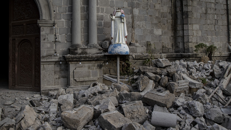
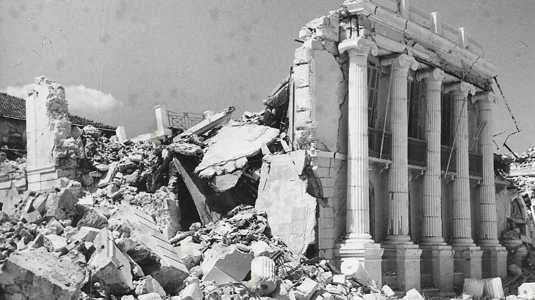
Italy is well known as one of the most seismically active parts of Europe, experiencing 39 significant earthquakes over the past century, according to EM-DAT. A timeline of Italian earthquakes published by The Guardian shows that 11 of these were powerful enough to have deadly consequences. The strongest quake to hit Italy in the 20th century occurred in 1908, with enough force to destroy the Sicilian city of Messina (pictured).
Italy's earthquakes, as Time explains, are caused by the tectonic boundary between the African and Eurasian plates. The same plate boundary, as the New York Times notes, also causes earthquakes on the other side of the Mediterranean Sea, in Algeria. This boundary drives extensive geological activity in the area and also powers Italy's famous volcanoes, like Etna and Vesuvius. The earthquakes that this plate boundary causes can also have wide-reaching effects. Science discusses one earthquake which struck near Rome in 2016, which was followed by over 2000 aftershocks. Aftershocks, according to the USGS, can continue for days or even years after a major earthquake, as the disturbed ground readjusts itself. Over time, they gradually decrease, as the tectonic plates settle, but shallower earthquakes usually cause many more aftershocks.
Mexico
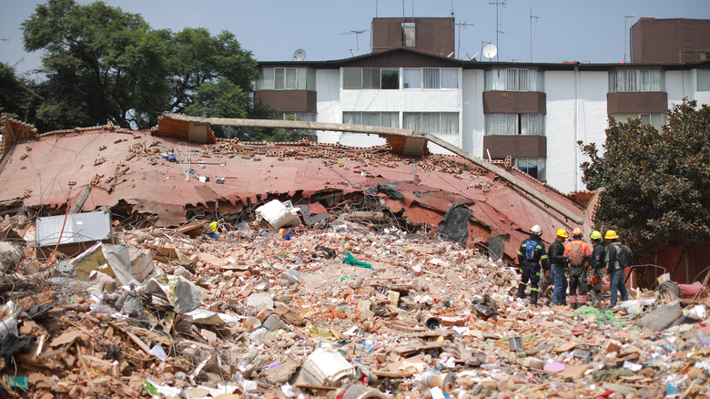
Situated on the Ring of Fire, earthquakes are a familiar occurrence in Mexico, with 41 significant quakes affecting the country over the past century, according to EM-DAT. As National Geographic explains, Mexico has the right geology to cause quakes that are both powerful and far-reaching, occasionally with catastrophic consequences. Nearly a quarter of all Mexico's earthquakes happen in the state of Oaxaca, which lies on top of a geologic feature known as the Tehuantepec fracture zone. This is a region where the Cocos plate slides below North America, in a subduction zone, but a sharp ridge on the sea floor makes this process bumpier than it should be.
One of the most powerful earthquakes Mexico felt in recent times, was the 2017 Puebla earthquake (pictured). According to the USGS, this quake struck near the town of Puebla, just south of Mexico City, with a magnitude of 7.1. Time elaborates on the resulting cataclysm, one of the deadliest earthquakes to strike Mexico in decades. The aftermath saw a small army of rescuers, including many volunteers, working tirelessly to help trapped victims, move fallen rubble, and deliver water and essential supplies.
Greece
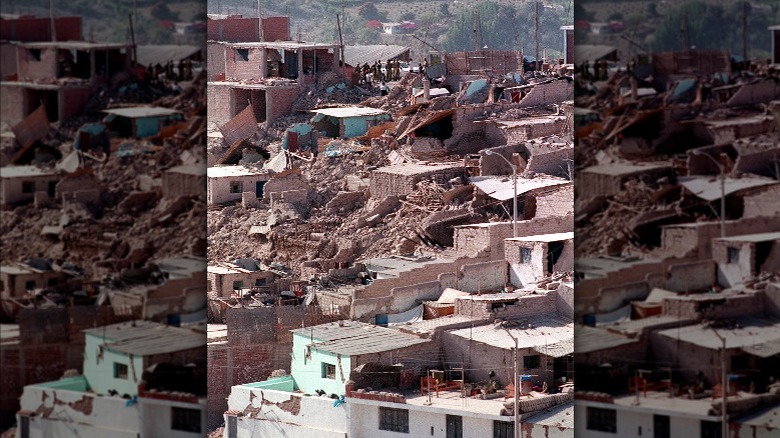
Greece may not be especially famous for its seismic activity, but, according to EM-DAT, 42 significant earthquakes hit the eastern Mediterranean country over the last century. In fact, a log run by the University of Athens shows that low magnitude tremors are recorded there quite regularly. As explained by a technical report from Helmholtz-Zentrum Potsdam, also known as the German Research Centre for Geosciences, this is because the land below Greece is riddled with complex tectonics and active geology. Several plate boundaries can be found in the Eastern Mediterranean, involving the large Eurasian, African, and Arabian plates, as well as the smaller Apulia, Anatolian, and Aegean plates. With so many plate boundaries in the area, there are plenty of fault lines from which earthquakes can emanate.
The resulting friction occurring at all of these plate boundaries, particularly between the African and Aegean plates, can cause some of the most severe earthquakes in Greece. Greek Reporter mentions that Greece suffers more earthquake damage than any other country in Europe, with the worst affected areas being around the coasts of Western Greece, between the islands of Corfu and Crete. The resulting earthquakes can be extremely damaging, such as the Kefalonia earthquake, which devastated the islands of Kefalonia, Zakynthos, and Ithaca in 1953 (pictured).
Peru
Situated on the Pacific Rim, Peru is another country known for its earthquakes, being struck by 51 noteworthy ones over the last century, according to EM-DAT. As an old article in Nature mentions, the earthquakes in Peru can cause severe damage, particularly around Peru's capital city of Lima. Historically, Lima has had a turbulent history with earthquakes. As mentioned in the book "Shaky Colonialism: The 1746 Earthquake-Tsunami in Lima, Peru, and Its Long Aftermath," one powerful earthquake in 1746 nearly leveled the entire city – the center of Spain's colonial activities in South America at the time.
As IRIS notes, Peru is particularly active because of the oceanic Nazca plate descending under the South American plate, in a region known as the Peru-Chile subduction zone. For as long as there have been humans living in the area, they've been affected by Peru's tectonic activity, and some signs of earthquake activity have left their mark on Inca ruins from pre-colonial times. An article in Science explains how the ruined city of Machu Picchu shows signs that it was hit by at least two major earthquakes while it was being constructed. The ability to withstand earthquakes was a key part of Inca architecture, as the URSA discusses. The result is that some of the most important Inca buildings were constructed with stones that fit together with remarkable precision, without even the tiniest gaps between stones, but with no mortar holding them together.
Japan
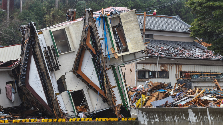
Japan is famous for its earthquakes, with EM-DAT listing 56 significant ones over the last century, and Live Science notes that there are around 1500 total quakes recorded in Japan every year. Japan is a literal hotbed of highly active geology, with numerous volcanoes and hot springs, as well as frequent earthquakes. The source of all this activity, as IRIS explains, is that Japan lies at the boundary of four tectonic plates – the Pacific, Philippine, Okhotsk, and Eurasian plates, with their subduction zones causing a collection of ocean trenches and troughs surrounding the archipelago of Japanese islands. Japan Rail also mentions that, with the country's regular seismic activity, Japan has a variety of safety countermeasures in place, including a disaster prevention system, evacuation centers, and an alert system that can notify all Japanese cell phones of imminent danger. Additionally, as the Japan Public Relations Office mentions, Japan has a long history of constructing buildings able to withstand regular earthquakes.
In the aftermath of a quake, people from all corners of Japanese society work together to help in recovery. Even the Yakuza. Famous for running organized crime in the shadier corners of Japanese society, Reuters reports that after the devastating 2011 earthquake in Japan, the Yakuza worked to provide food, water, and other supplies to people in evacuation centers. While some criticized their actions as self-serving, the Yakuza themselves insisted that their only intent was to help people in need.
Turkey
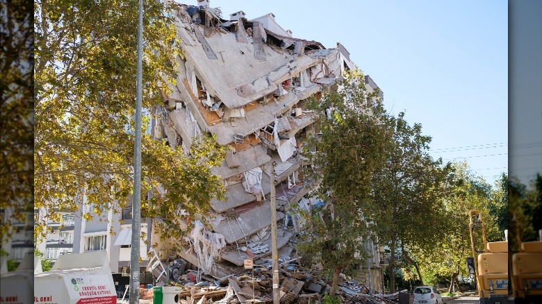
Turkey has so many earthquakes that they mostly go unremarked upon, but over the last century, 104 significant quakes have rocked the country, according to EM-DAT. As Daily Sabbah explains, Turkey sits atop its own tectonic plate, the Anatolian plate, surrounded by the African, Eurasian, and Arabian plates. As a result, Turkey is extremely prone to quakes, with over 33,000 recorded in 2020 alone, caused by the motion of the surrounding tectonic plates squeezing the Anatolian plate as they shift.
The most active area, noted by National Geographic, is the North Anatolian fault, which lies near Istanbul. Major ruptures happen along this fault line with some regularity, meaning that Turkey's largest and most venerable city is always at some risk of being affected by seismic activity.
Elsewhere in Turkey, earthquakes also happen along the East Anatolian fault, while the western side of the country feels tremors from a boundary between the Anatolian plate and the Aegean plate. With so many quake-prone regions on all sides of the country, it's no surprise that Turkish people learn how to prepare for natural disasters from an early age.
Indonesia
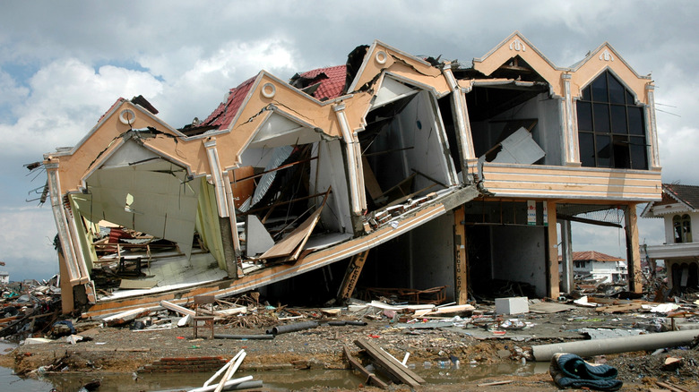
Indonesia is one of the world's most geologically volatile places, with 127 notable earthquakes over the last century, per EM-DAT. The reason, as NBC News explains, is that the country lies at the intersection of two of the world's largest tectonic regions. An island archipelago, Indonesia is where the Alpide Belt meets the Ring of Fire. The result is cataclysmic, causing some of the fiercest earthquakes and volcanoes on Earth. Beneath Indonesia is a collision between the Indian, Australian, Eurasian, Sunda, and Pacific plates, resulting in powerful earthquakes like one violent rupture in 2004 (pictured), which reached a magnitude of 9.1.
The geologic activity below Indonesia was also responsible for the infamous volcano Krakatoa (via the Smithsonian Institute). As an added hazard, being surrounded by the ocean, the powerful earthquakes of Indonesia can also cause tsunamis, devastating coastal communities. As UNICEF mentions, this is exactly what happened in 2018, when a magnitude 7.4 earthquake triggered a tsunami that affected over 1.5 million people and displaced half the population of the city of Palu.
Iran
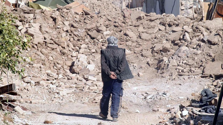
Iran is a high-risk area for tectonic activity, with 138 significant earthquakes recorded over the last century, via EM-DAT. The Earth System Knowledge Platform elaborates that the frequent quakes in Iran originate from deep below the ground and can have potentially devastating surface effects. One magnitude 7.7 earthquake hit Iran in 2013, emanating from a depth of 45 miles (73 km) underground, with its effects being strong enough to be felt as far away as New Delhi, the capital of India. According to the University of Buffalo's Multidisciplinary Center for Earthquake Engineering Research, 90% of Iran is seismically active, with major fault lines crossing through the country.
Iran's earthquakes, as Smithsonian Magazine explains, are the result of the country sitting right on top of the boundary between the Eurasian and Arabian tectonic plates. The result is that earthquakes feature prominently throughout the country's history. What's more, the stresses in Earth's crust below Iran mean that quakes can occur far away from the plate boundary itself. These "intraplate earthquakes" are smaller and rarer, happening when enough stress builds up to make the plate start to buckle under pressure.
China
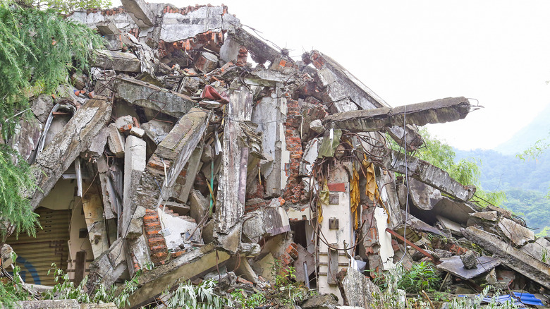
China is the world's 3rd largest country by area and experiences more earthquakes than anywhere else. According to EM-DAT, 191 quakes have rocked China over the past century – substantially more than any other country on Earth. A travel guide by China Highlights mentions how Chinese earthquakes are most likely to strike the Sichuan and Yunnan provinces, as well as the Tibet Autonomous Region. However, as Science Museums of China explains, earthquakes have been recorded in every part of the country except Guizhou, Zhejiang, and Hong Kong. These quakes emanate from fracture zones where the Pacific, Indian, and Philippine plates are colliding.
Surviving accounts from Ancient China contain the earliest known earthquake in recorded history. Per USGS, this quake struck Shangdong Province in the year 1831 B.C.E. More recently in history, China was also stricken by the deadliest earthquake in recorded history. History explains that it would become known as the Jiajing Great Earthquake, named after China's ruler at the time, Emperor Jiajing of the Ming Dynasty. This calamitous quake hit Shaanxi province in 1556, killing around 830,000 people.
As a result of such a long history of earthquakes, China is home to some traditional architecture designed to withstand tremors. As the Times of Malta discusses, Ancient Chinese architects developed a way to construct buildings with a system of interlocking flower-shaped brackets. Known as dougong, the pieces fit together with no nails and were first developed around 2,500 years ago.